

Thursday, December 5, 2013

Tuesday, November 26, 2013
NIST Report on Joplin Tornado
Technical Investigation of the May 22, 2011, Tornado in Joplin MO
The above link will take you to a 429 page VERY detailed DRAFT of the National Institute of Standards and Technology (NIST) investigation of the Joplin MO tornado. In it you will find details on emergency communications, building performance (St. Johns, Walmart, Home Depot and more), designated safe areas, etc. It's a long read with a ton of information.
Abstract:
This is the final report of the National Institute of Standards and Technology (NIST) investigation of the May 22, 2011, tornado in Joplin, Missouri, conducted under the National Construction Safety Team Act. This report describes the wind field of the tornado and how the wind pressures and windborne debris damaged and destroyed thousands of buildings; the emergency communications before and during the tornado and how the public responded; the influence of tornado hazards and public response and building and designated shelter area performance on survival and injury; and areas of current building and emergency communications codes, standards and practices that warrant revision. Also described in this report is the means by which NIST reached its conclusions. NIST collected large numbers of documents, photographs, videos, and building plans; developed a computer model of the wind field of the tornado as it crossed the City of Joplin; analyzed the performance of a range of building types for life safety and functionality; interviewed many survivors of the tornado, developed an evidence-based explanation for decisions made and actions taken by the public in response to the tornado; and analyzed the factors affecting life safety outcomes. The report outlines 47 findings related to the May 22, 2011, Joplin tornado and concludes with a list of 16 recommendations for action in areas of improved measurement and characterization of tornado hazards, new methods for tornado resistant design of buildings, enhanced guidance for community tornado sheltering, and improved and standardized emergency communications.
Friday, November 22, 2013
What It Is Like Getting Hit By The Outer Edge Of An EF-4 Tornado ***Adult Language***
*****WARNING: ADULT LANGUAGE*****
This is from the Washington, IL tornado on 11/17/13. This family survived an EF-4 tornado. It appears they were on the outer edge of this 170-190 MPG winded beast. Adult language, so watch at your own discretion. Prayers go out to my family and friends in the Pekin/Washington IL area. I grew up in Pekin, before moving away when I was 15 years old.
This is from the Washington, IL tornado on 11/17/13. This family survived an EF-4 tornado. It appears they were on the outer edge of this 170-190 MPG winded beast. Adult language, so watch at your own discretion. Prayers go out to my family and friends in the Pekin/Washington IL area. I grew up in Pekin, before moving away when I was 15 years old.
Monday, November 18, 2013
How A Tornado Can Hit One House And Miss Another
This image posted by The Chicago Tribune from the November 17th Washington, IL tornado shows the unfortunate results of a farm house taking a direct hit. But what is incredible is the spiral patterns in the field. You can see that there are portions of the field that didn't get hit with the swirling funnel. It easily demonstrates how one home could still be standing and another could be leveled.

Friday, August 2, 2013
Scattered Strong to Severe Storms Possible

- Limited tornado risk
- Elevated hail risk
- Elevated thunderstorm wind damage risk
- Elevated flooding risk
- Significant lightning risk
You should stay tuned to local weather forecasts. Make sure your NOAA All Hazards Radio is on and backed up by battery. If you don't own a NOAA All Hazards Radio, you should. Click the link for a previous blog post on selecting one.
Thursday, June 27, 2013
Severe Storms Possible Later Today and Tonight
 |
| SPC Day 1 Tornado Outlook |
- Limited tornado risk
- Elevated hail risk
- Elevated thunderstorm wind damage risk
- Elevated lightning risk
- Significant excessive heat risk
You should stay tuned to local weather forecasts. Make sure your NOAA All Hazards Radio is on and backed up by battery. If you don't own a NOAA All Hazards Radio, you should. Click the link for a previous blog post on selecting one.
Wednesday, June 26, 2013
Severe Weather Possible on Thursday 6/26
There is a possibility of strong to severe storms developing tomorrow. We will post more information regarding this threat tomorrow, but wanted to give everyone a heads up.
Tuesday, June 11, 2013
Video Footage of EF-5 El Reno Tornado
Video footage captured during the El Reno, OK tornado on May 31, 2013. Apparently this was captured by employees and guests of Tempest Tours (storm chasing tour group).
Tuesday, June 4, 2013
Storm Chaser Locations During El Reno Tornado
This is a video showing the location of storm chasers combined with the estimated tornado damage path of the El Reno, OK tornado on 5/31/13. This is only spotters who use Spotter Network to broadcast their position and tie that with ground truth reports, which means there were MANY more out there. The Spotter Network reports are available to those interested, such as the National Weather Service, so they have this valuable ground truth information that radar can't see.
El Reno Tornado Now Largest On Record
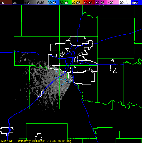
The El Reno, OK tornado is now the widest tornado on record at 2.6 miles wide. It is now rated EF-5 based on mobile Doppler radar readings, with winds up to 296 MPG. Read more from The Washington Post.
Friday, May 31, 2013
UPDATED: Strong to Severe Thunderstorms This Afternoon and Evening

Strong to severe thunderstorms will develop this afternoon into the evening. The Storm Prediction Center has most of MO and OK, SE KS and NW AR in a slight risk for severe weather, with SE KS, much of OK and extreme SW MO in a moderate risk box for severe weather. The slight risk area is listed with a 5-10% chance of a tornado, with the moderate risk area showing 15%.
The Springfield NWS office notes that the most likely time for storms to impact the Ozarks is between 2pm and 10pm this evening. The risks include:
- Elevated tornado risk
- Elevated hail risk (up to golf ball sized hail)
- Elevated thunderstorm wind damage risk (up to 70MPH wind gusts)
- Elevated flooding risk
- Significant lightning risk
- Limited non-thunderstorm wind damage risk
Rainfall amounts are expected from 1 to 4 inches, so please pay attention to flooding possibilities.
You should stay tuned to local weather forecasts. Make sure your NOAA All Hazards Radio is on and backed up by battery. If you don't own a NOAA All Hazards Radio, you should. Click the link for a previous blog post on selecting one.
Strong to Severe Thunderstorms This Afternoon and Evening
The Springfield NWS office notes that the most likely time for storms to impact the Ozarks is between 2pm and 10pm this evening. The risks include:
- Elevated tornado risk
- Elevated hail risk (up to golf ball sized hail)
- Elevated thunderstorm wind damage risk (up to 70MPH wind gusts)
- Elevated flooding risk
- Significant lightning risk
- Limited non-thunderstorm wind damage risk
Rainfall amounts are expected from 1 to 4 inches, so please pay attention to flooding possibilities.
You should stay tuned to local weather forecasts. Make sure your NOAA All Hazards Radio is on and backed up by battery. If you don't own a NOAA All Hazards Radio, you should. Click the link for a previous blog post on selecting one.
Thursday, May 30, 2013
UPDATED: Severe Weather Expected This Afternoon and Tonight

Conditions have become more unstable, and the severe weather threat has increased for the Ozarks. There is an active Tornado Watch until 9PM tonight that includes SW MO and surrounding areas. The National Weather Service in Springfield now list today's risks as:
- Elevated tornado risk
- Elevated hail risk
- Elevated thunderstorm wind damage risk
- Significant flooding risk
- Significant lightning risk
You should stay tuned to local weather forecasts. Make sure your NOAA All Hazards Radio is on and backed up by battery. If you don't own a NOAA All Hazards Radio, you should. Click the link for a previous blog post on selecting one.
Conditional Risk For Severe Weather Later Today and Tonight

The Storm Prediction Center has most of MO, KS, OK and NW AR in a slight risk box for severe weather, and part of S KS and a good part of OK in a moderate risk box. They list the tornado probability in much of the Ozarks at 5%, however, the Joplin area is in a 10% hatched area for stronger tornadoes.
The National Weather Service in Springfield, MO lists the threats as:
- Limited tornado risk
- Limited non thunderstorm wind risk
- Significant lightning risk
- Elevated hail risk
- Elevated thunderstorm wind damage risk
- Limited flooding risk
You should stay tuned to local weather forecasts. Make sure your NOAA All Hazards Radio is on and backed up by battery. If you don't own a NOAA All Hazards Radio, you should. Click the link for a previous blog post on selecting one.
Monday, May 20, 2013
Severe Storms Expected Later Today

- Elevated tornado risk
- Significant hail risk
- Significant thunderstorm wind damage risk
- Elevated flooding risk
- Significant lightning risk
Storms are expected to develop across eastern KS and OK again later this afternoon and move across the Ozarks into the overnight hours. Golf ball sized hail, damaging winds in excess of 60 MPH and tornadoes are possible.
You should stay tuned to local weather forecasts. Make sure your NOAA All Hazards Radio is on and backed up by battery. If you don't own a NOAA All Hazards Radio, you should. Click the link for a previous blog post on selecting one.
Sunday, May 19, 2013
Strong Tornadoes Possible Today - Sunday 5/19/13

The Springfield NWS lists the threats as:
- Elevated tornado risk
- Significant hail risk
- Significant thunderstorm wind damage risk
- Limited flooding risk
- Significant lightning risk
- Limited non-thunderstorm wind risk
- Limited fog risk
This could be our first big spring storm system, and it will continue through Monday. Please be alert and prepared. Run through your safety plan so you can act on it with short notice.
***Joplin area folks, your weather alert radios may not function properly, please see the NWS URGENT statement regarding the over the air alerting system.***
You should stay tuned to local weather forecasts. Make sure your NOAA All Hazards Radio is on and backed up by battery. If you don't own a NOAA All Hazards Radio, you should. Click the link for a previous blog post on selecting one.
Wednesday, May 15, 2013
Prepare For Severe Weather Now

Here is a detailed posting about what you should look for.
Please consider this, and don't wait until the severe weather is here. Prepare now so you can stress less later.
Saturday, May 4, 2013
10 Year Anniversary of May 4, 2003 Outbreak
Today is the 10 year anniversary of the May 4, 2003 tornado outbreak. Here is the Storm Prediction Center storm report from that day. Here is the Springfield National Weather Service event review. I also posted a blog post about that day, which is really what got me back into storm spotting after I had taken a break from it for a while. Below is a video from Tom Trtan and Nick Penka as one of the large tornadoes moved towards Clever and Battlefield. I know that there is cold weather and snow right now, but please remember it is prime storm season. If you don't own a NOAA All Hazards Radio, you should.
Wednesday, April 17, 2013
Severe Weather Likely Today/Tornado Watch

The Storm Prediction Center has all of the Ozarks in a slight risk box for severe weather today, with much of MO, SE KS and a good portion of OK in a MODERATE risk box for severe weather. What does that mean? Much of the area has at least a 10% chance of a tornado. The Joplin and Springfield areas on up across the center portion of MO and NE OK are in the 10% area and SE KS and much of OK in the 15% chance area. Storms may come in two waves today. Let's hope conditions change, and you prepared for nothing.
The National Weather Service office in Springfield MO states that storms forming this afternoon could bring large hail (half dollar), frequent lightning and damaging winds. Later this afternoon supercell thunderstorm development will be possible. Golfball sized hail, damaging winds and possible tornado development are all possible. The risks specifically listed are:
- Elevated tornado risk
- Significant hail risk
- Elevated thunderstorm wind damage risk
- Elevated flooding risk
- Significant lightning risk
- Limited non-thunderstorm wind damage risk
You should stay tuned to local weather forecasts. Make sure your NOAA All Hazards Radio is on and backed up by battery. If you don't own a NOAA All Hazards Radio, you should. Click the link for a previous blog post on selecting one.
Tuesday, April 16, 2013
Severe Weather Expected - Wednesday 4/17/13

You should stay tuned to local weather forecasts. Make sure your NOAA All Hazards Radio is on and backed up by battery. If you don't own a NOAA All Hazards Radio, you should. Click the link for a previous blog post on selecting one.
Tuesday, April 9, 2013
Strong to Severe Storms Possible This Evening
 The Storm Prediction Center has much of MO, KS and OK in a slight risk box for severe weather. The Springfield National Weather Service office lists the threats in SW MO and SE KS as follows:
- Limited Tornado Risk
- Elevated Hail Risk
- Elevated Thunderstorm Wind Damage Risk
- Limited Flooding Risk
- Significant Lightning Risk
You should stay tuned to local weather forecasts. Make sure your NOAA All Hazards Radio is on and backed up by battery. If you don't own a NOAA All Hazards Radio, you should. Click the link for a previous blog post on selecting one.
Wednesday, February 20, 2013
Snow/Sleet/Ice Expected Tonight and Tomorrow
.png) |
| Springfield NWS Graphic |
Prepare now, and be safe.
You should stay tuned to local weather forecasts. Make sure your NOAA All Hazards Radio is on and backed up by battery. If you don't own a NOAA All Hazards Radio, you should. Click the link for a previous blog post on selecting one.
Wednesday, February 13, 2013
February 10, 2013 Hattiesburg MS EF-4 Tornado Event
 |
| Photo by Basehunters/TVNWeather.com |
Tuesday, February 12, 2013
Tuesday, January 29, 2013
Severe Storms Possible Today

Tornado Watch until 3pm
Severe storms are possible this morning and later today in the Ozarks. The Storm Prediction Center has the area listed in a slight risk box for severe weather, including the possibility for tornadoes. The Springfield National Weather Service lists the risk today as:
- Elevated tornado risk
- Elevated hail risk
- Significant thunderstorm wind damage risk
- Elevated lightning risk
- Limited non thunderstorm wind risk
Monday, January 28, 2013
Strong to Severe Storms Overnight and Tuesday
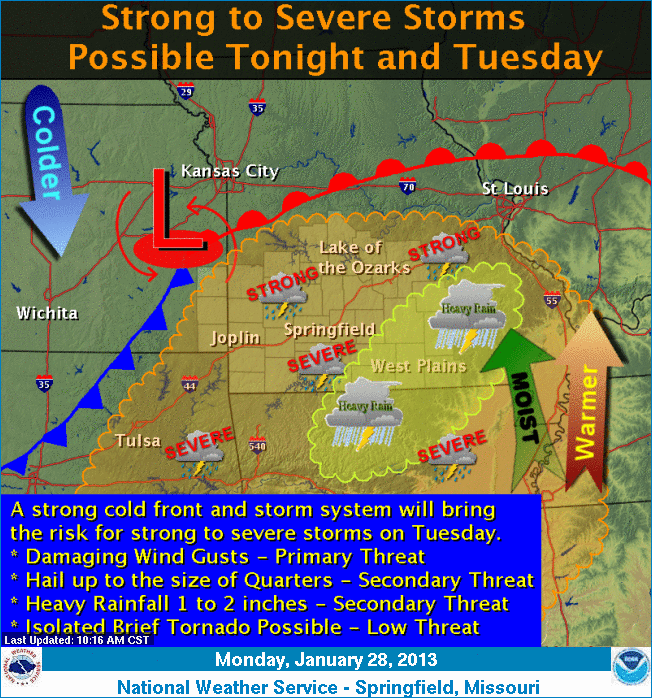
- Limited tornado risk
- Limited thunderstorm wind damage
- Limited lightning risk
- Limited non-thunderstorm wind damage
These risk are for the Day 1 outlook. There is a good chance the Tuesday morning outlook will contain stronger language. To be clear, for SW MO there will be a risk just after midnight tonight or so, then a bigger risk Tuesday in the late morning hours or noon.
You should stay tuned to local weather forecasts. Make sure your NOAA All Hazards Radio is on and backed up by battery. If you don't own a NOAA All Hazards Radio, you should. Click the link for a previous blog post on selecting one.
Sunday, January 27, 2013
Tornadoes Possible Tuesday 1/29/13

You should stay tuned to local weather forecasts. Make sure your NOAA All Hazards Radio is on and backed up by battery. If you don't own a NOAA All Hazards Radio, you should. Click the link for a previous blog post on selecting one.
Monday, January 7, 2013
 |
| Video screen capture of lightning lit tornado in Republic, MO. January 7, 2008. |
Please remember that tornadoes can happen any time of the year, and especially in the Spring, which isn't that far away. If you don't already own a NOAA All Hazards Radio, please get one soon.
Initial post indicating isolated tornadoes...boy was that forecast conservative!
Event overview with link to chase log.
Event update.
Hard safety lesson learned...a post describing an error in judgement.
Excellent "hook echo" example from Republic, MO tornado.
Wednesday, January 2, 2013
Please Prepare And Be Aware...Let's Break The Record

Folks, this is a record we want to break, and it looks like we are going to do it. There were approximately 27 tornadoes on Christmas day (2012) with no reported fatalities. Bravo to our National Weather Services offices and local media! I feel confident that "situational awareness" is the reason lives were saved on Christmas day, and why we are on track to beat this record.
Please prepare and be aware... Spring is coming. If you don't own a NOAA All Hazards Radio, you should. Click the link for a previous blog post on selecting one.
Subscribe to:
Posts (Atom)