Monday, October 25, 2010

Severe Weather Possible Overnight - Monday 10/25/10

There is a slight risk of severe storms after midnight tonight in the region. The best chances are between the highway 71 and highway 65 corridor. This is an overnight risk, the perfect time to check your all hazards radio to make sure it's working.

Risks:
Thunderstorm winds greater than 60MPH - Elevated
Lightning - Limited
Tornadoes - Limited


You should stay tuned to local weather forecasts. Make sure your NOAA All Hazards Radio is on and backed up by battery. If you don't own a NOAA All Hazards Radio, you should. Click the link for a previous blog post on selecting one.

Sunday, October 24, 2010

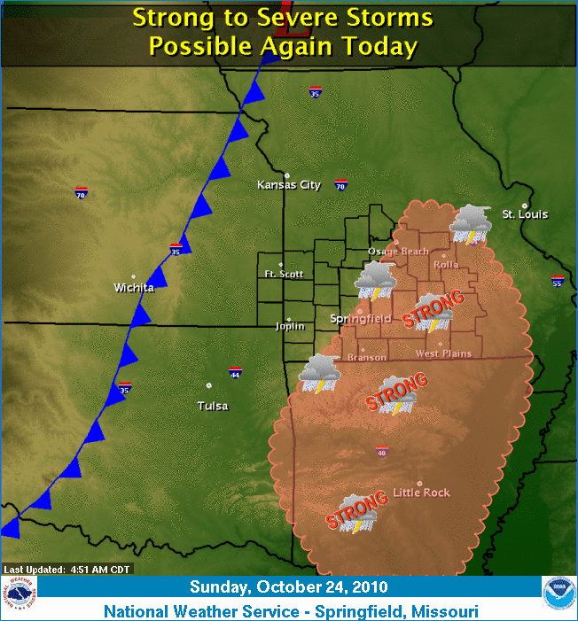
Severe Storms Possible - Sunday 10/24/10

Strong to severe storms are possible this afternoon and evening in the region. The best chances are along and east of highway 65.

Risks:
Thunderstorm winds greater than 60MPH - Elevated
Lightning - Limited
Hail to the size of quarters - Elevated
Tornadoes - Limited


You should stay tuned to local weather forecasts. Make sure your NOAA All Hazards Radio is on and backed up by battery. If you don't own a NOAA All Hazards Radio, you should. Click the link for a previous blog post on selecting one.
Saturday, October 23, 2010

Severe Storms Possible - Saturday 10/23/10

Strong to severe storms are possible this afternoon and evening in the region.

Risks:
Thunderstorm winds greater than 60MPH - Elevated
Lightning - Elevated
Hail larger than quarters - Elevated
Flooding - Limited


You should stay tuned to local weather forecasts. Make sure your NOAA All Hazards Radio is on and backed up by battery. If you don't own a NOAA All Hazards Radio, you should. Click the link for a previous blog post on selecting one.

Friday, September 17, 2010

Confirmed Tornado in Nixa, MO 9/15/2010

A confirmed EF-0 tornado touched down in Nixa, Mo on September 15, between 10:50 and 10:55pm. The damage path was 100 yards wide and 1/2 mile long. Numerous trees were damaged, including limbs of up to 12 inches. Wind estimates are 80-85MPH.

Interestingly enough, had this tornado stayed on the ground, it would have taken an almost identical path as the EF-0 April 9th, 2009 and the F4 on November 29, 1991. Also the the same path as the funnel cloud in the pictures from the end of the OzarkStorms May 4, 2003 event blog posting. I guess Nixa has it's own little Tornado Alley!

There are pictures from the NWS review of this tornado that show damage other than the tree damage listed, so I do not know what was destroyed. If you visit the picture link, there are different headers at the top of the page that detail this event, such as Summary, Synopsis, Survey, etc. There is quite a bit of interesting reading there.

Be safe!

Wednesday, September 15, 2010

Severe Storms Possible - Wednesday 9/15/10

Severe weather possible this late afternoon and evening. The tornado risk is mostly west of Highway 71 in western MO.

Risks:
Winds greater than 60MPH - Elevated
Lightning - Significant
Hail Larger Than Quarters - Elevated
Flooding - Limited
Tornadoes - Limited

You should stay tuned to local weather forecasts. Make sure your NOAA All Hazards Radio is on and backed up by battery. If you don't own a NOAA All Hazards Radio, you should. Click the link for a previous blog post on selecting one.
Published with Blogger-droid v1.5.9

Friday, September 10, 2010

Severe Storms Likely - Friday 9/10/10

Severe weather is likely to occur in SW MO this afternoon, evening and overnight.

Risks:
Winds to 70 - Elevated
Lightning - Significant
Hail Larger Than Quarters - Elevated
Flooding - Elevated
Tornadoes - Limited

You should stay tuned to local weather forecasts. Make sure your NOAA All Hazards Radio is on and backed up by battery. If you don't own a NOAA All Hazards Radio, you should. Click the link for a previous blog post on selecting one.

Monday, July 12, 2010

Severe Storms Likely - Monday 7/12/10

There are several forecast indications that suggest that a storm complex could impact portions of extreme southeast Kansas and the Missouri Ozarks this afternoon and evening. Damaging wind gusts in excess of 70 mph...large hail up to the size of half dollars...and tornadoes will all be possible hazards with these storms. Heavy rain leading to flash flooding will also be possible.

Risks:
Winds to 70 - Significant
Lightning - Elevated
Hail to 1/2 Dollar Size - Elevated
Flooding - Elevated
Tornadoes - Elevated

You should stay tuned to local weather forecasts. Make sure your NOAA All Hazards Radio is on and backed up by battery. If you don't own a NOAA All Hazards Radio, you should. Click the link for a previous blog post on selecting one.