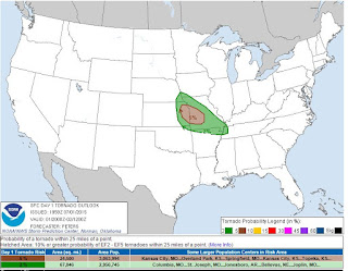
 The Storm Prediction Center has much of MO and other areas to the SE in a slight risk zone for
 severe weather. This includes the possibility of isolated tornadoes. A good portion of MO is in a 5% risk area for that development. The National Weather Service in Springfield, MO lists the hazards as:
- Limited tornado risk
- Elevated hail risk
- Elevated thunderstorm wind damage risk
- Significant flooding risk
- Significant lighting risk
- Limited excessive heat risk
Storms are expected to develop later this afternoon into the evening hours. Severe weather is also possible Thursday afternoon and evening.
No comments:
Post a Comment