Thursday, December 23, 2010

Christmas Snow in SW MO? Maybe!

The National Weather Service and local meteorologists are calling for winter precipitation Christmas Eve into Christmas. The language seems to be a little vague, but leaning towards some snow. Wouldn't that be fantastic!

Merry Christmas everyone!

Monday, November 29, 2010

Yazoo City, MS Hit Second Tornado This Year

Yazoo City, MS has been hit by a second tornado this year. Early reports indicate structural damage, but no reports of injuries have come in as of posting time. On April 24, 2010, this town was devastated by an EF-4 tornado, which was very well documented on this season's Storm Chasers on Discovery. Below is a video by Reed Timmer and team from the EF-4 in April.

Prayers go out to those in Yazoo City and other areas who are suffering from tonights storms.

UPDATED REPORT from Accuweather.


Wednesday, November 24, 2010

Tornado Watch - Wednesday 11/24/10

Tornado watch until 10 p.m.
Published with Blogger-droid v1.6.5

Tuesday, November 23, 2010

Severe Weather Possible - Wednesday 11/24/2010

Strong to severe storms will be possible late Wednesday afternoon into Wednesday night. Marginal instability and extreme wind shear will result in an elevated risk for severe thunderstorms according to the NWS Hazardous Weather Outlook.

Risks:
Damaging straight line winds
Large hail
Heave rainfall
A few tornadoes


You should stay tuned to local weather forecasts. Make sure your NOAA All Hazards Radio is on and backed up by battery. If you don't own a NOAA All Hazards Radio, you should. Click the link for a previous blog post on selecting one.

Monday, October 25, 2010

Severe Weather Possible Overnight - Monday 10/25/10

There is a slight risk of severe storms after midnight tonight in the region. The best chances are between the highway 71 and highway 65 corridor. This is an overnight risk, the perfect time to check your all hazards radio to make sure it's working.

Risks:
Thunderstorm winds greater than 60MPH - Elevated
Lightning - Limited
Tornadoes - Limited


You should stay tuned to local weather forecasts. Make sure your NOAA All Hazards Radio is on and backed up by battery. If you don't own a NOAA All Hazards Radio, you should. Click the link for a previous blog post on selecting one.

Sunday, October 24, 2010

Severe Storms Possible - Sunday 10/24/10

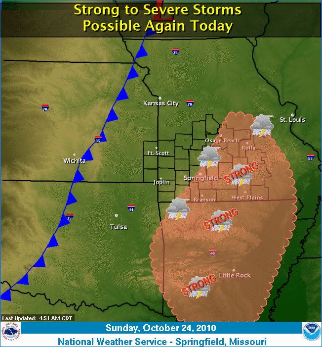
Strong to severe storms are possible this afternoon and evening in the region. The best chances are along and east of highway 65.

Risks:
Thunderstorm winds greater than 60MPH - Elevated
Lightning - Limited
Hail to the size of quarters - Elevated
Tornadoes - Limited


You should stay tuned to local weather forecasts. Make sure your NOAA All Hazards Radio is on and backed up by battery. If you don't own a NOAA All Hazards Radio, you should. Click the link for a previous blog post on selecting one.

Saturday, October 23, 2010

Severe Storms Possible - Saturday 10/23/10

Strong to severe storms are possible this afternoon and evening in the region.

Risks:
Thunderstorm winds greater than 60MPH - Elevated
Lightning - Elevated
Hail larger than quarters - Elevated
Flooding - Limited


You should stay tuned to local weather forecasts. Make sure your NOAA All Hazards Radio is on and backed up by battery. If you don't own a NOAA All Hazards Radio, you should. Click the link for a previous blog post on selecting one.

Friday, September 17, 2010

Confirmed Tornado in Nixa, MO 9/15/2010

A confirmed EF-0 tornado touched down in Nixa, Mo on September 15, between 10:50 and 10:55pm. The damage path was 100 yards wide and 1/2 mile long. Numerous trees were damaged, including limbs of up to 12 inches. Wind estimates are 80-85MPH.

Interestingly enough, had this tornado stayed on the ground, it would have taken an almost identical path as the EF-0 April 9th, 2009 and the F4 on November 29, 1991. Also the the same path as the funnel cloud in the pictures from the end of the OzarkStorms May 4, 2003 event blog posting. I guess Nixa has it's own little Tornado Alley!

There are pictures from the NWS review of this tornado that show damage other than the tree damage listed, so I do not know what was destroyed. If you visit the picture link, there are different headers at the top of the page that detail this event, such as Summary, Synopsis, Survey, etc. There is quite a bit of interesting reading there.

Be safe!

Wednesday, September 15, 2010

Severe Storms Possible - Wednesday 9/15/10

Severe weather possible this late afternoon and evening. The tornado risk is mostly west of Highway 71 in western MO.

Risks:
Winds greater than 60MPH - Elevated
Lightning - Significant
Hail Larger Than Quarters - Elevated
Flooding - Limited
Tornadoes - Limited

You should stay tuned to local weather forecasts. Make sure your NOAA All Hazards Radio is on and backed up by battery. If you don't own a NOAA All Hazards Radio, you should. Click the link for a previous blog post on selecting one.
Published with Blogger-droid v1.5.9

Friday, September 10, 2010

Severe Storms Likely - Friday 9/10/10

Severe weather is likely to occur in SW MO this afternoon, evening and overnight.

Risks:
Winds to 70 - Elevated
Lightning - Significant
Hail Larger Than Quarters - Elevated
Flooding - Elevated
Tornadoes - Limited

You should stay tuned to local weather forecasts. Make sure your NOAA All Hazards Radio is on and backed up by battery. If you don't own a NOAA All Hazards Radio, you should. Click the link for a previous blog post on selecting one.

Monday, July 12, 2010

Severe Storms Likely - Monday 7/12/10

There are several forecast indications that suggest that a storm complex could impact portions of extreme southeast Kansas and the Missouri Ozarks this afternoon and evening. Damaging wind gusts in excess of 70 mph...large hail up to the size of half dollars...and tornadoes will all be possible hazards with these storms. Heavy rain leading to flash flooding will also be possible.

Risks:
Winds to 70 - Significant
Lightning - Elevated
Hail to 1/2 Dollar Size - Elevated
Flooding - Elevated
Tornadoes - Elevated

You should stay tuned to local weather forecasts. Make sure your NOAA All Hazards Radio is on and backed up by battery. If you don't own a NOAA All Hazards Radio, you should. Click the link for a previous blog post on selecting one.

Thursday, May 20, 2010

Severe Weather Possible Thursday 5/20

There is a possibility of severe weather in SE KS and SW MO later this afternoon. The likelihood will increase if cloud cover breaks and the sun heats things up. The risks include:
  • Elevated risk for flooding
  • Limited risk for tornado development
  • Elevated risk of lightning
  • Elevated risk of hail
  • Limited risk of thunderstorm winds
*********************************************************************
You should stay tuned to local weather forecasts. Make sure your NOAA All Hazards Radio is on and backed up by battery. If you don't own a NOAA All Hazards Radio, you should. Click the link for a previous blog post on selecting one.

Wednesday, May 19, 2010

Severe Weather Possible Today

The National Weather Service has the following hazards listed for this afternoon and evening:
  • Limited Tornado Risk
  • Elevated Hail Risk
  • Limited Thunderstorm Wind Risk
  • Elevated Flooding Risk
Oklahoma is under the gun again today with a severe weather outbreak imminent. Some of this may push into far SW MO later tonight. Currently far SW MO isn't even in a slight risk box according to the Storm Prediction Center, but that could change later today. Pay attention to the weather.

*********************************************************************
You should stay tuned to local weather forecasts. Make sure your NOAA All Hazards Radio is on and backed up by battery. If you don't own a NOAA All Hazards Radio, you should. Click the link for a previous blog post on selecting one.

Tuesday, May 11, 2010

Slight Risk for Severe Weather After 4 P.M.

The National Weather Service Day 1 Outlook calls for the possibility of severe weather this afternoon and evening. The risks include:
  • Limited risk for tornadoes
  • Elevated risk of hail up to golf ball size
  • Elevated risk for Tstorm wind gusts of 70 MPH
  • Elevated risk for flash flooding
*********************************************************************
You should stay tuned to local weather forecasts. Make sure your NOAA All Hazards Radio is on and backed up by battery. If you don't own a NOAA All Hazards Radio, you should. Click the link for a previous blog post on selecting one.

Monday, May 10, 2010

Severe Weather/Tornadoes Expected This Afternoon

The Storm Prediction Center and the National Weather Service are calling for an EXTREME SEVERE WEATHER event. It is time to invoke situational awareness, think and prepare. Please do not get caught off guard this afternoon and evening if this situation pans out.

The risks are:
  • Tornadoes with the potential of LONG TRACK STRONG TORNADOES
  • Large hail with golg ball size hail likely and baseball size hail possible
  • Damaging Winds near 70 MPH
  • Heavy rain with localized flash flooding
Folks in SE KS, NE OK, NW AR and extreme SW MO are in the highest risk area. Again, please think ahead and plan now.

**********************************************************************
You should stay tuned to local weather forecasts. Make sure your NOAA All Hazards Radio is on and backed up by battery. If you don't own a NOAA All Hazards Radio, you should. Click the link for a previous blog post on selecting one.

Sunday, May 9, 2010

Supercells and Strong Tornadoes Expected Monday

More to follow on Monday...but from the Storm Prediction Center:
SUPERCELLS WITH STRONG TORNADOES AND VERY LARGE HAIL ARE EXPECTED MONDAY LATE
AFTERNOON  AND EVENING ACROSS PARTS OF OK/KS INTO SOUTHWEST MO...

Tuesday, May 4, 2010

7 Year Anniversary of May 4th, 2003 Outbreak

Today marks the seven year anniversary of the May 4th, 2003 outbreak. This day is burned into my memory because of the impact it had on friends and loved ones. It was also the day I decided to become active again in storm spotting.

You can find my event review here.

You can find the National Weather Service event review here.

Be safe.

Friday, April 30, 2010

Severe Storms Likely - Friday 4/30/10

Updated: 12:52PM

Severe storms are likely this afternoon and tonight. The NWS Hazardous Weather Outlook calls for the following risks today:

    Risk Level
    • Hail - Significant
    • Winds - Extreme
    • Tornado - Elevated
    • Flooding - Limited
    The Storm Prediction Center in Norman, OK puts our area in a slight risk box for the day.

    You should stay tuned to local weather forecasts. Make sure your NOAA All Hazards Radio is on and backed up by battery. If you don't own a NOAA All Hazards Radio, you should. Click the link for a previous blog post on selecting one.


    Friday, April 23, 2010

    Significant Risk of Severe Storms Today Into Tomorrow

    The Storm Prediction Center has SW MO in a slight risk box with a moderate risk box just south of the Arkansas border. The NWS office in Springfield MO is calling for severe weather in our area. As of 5:48 a.m. the risks are as follows:
    • Elevated risk for tornadoes
    • Significant risk for hail
    • Elevated risk for thunderstorm wind gusts
    • Elevated risk for lighting
    You should stay tuned to local weather forecasts. Make sure your NOAA All Hazards Radio is on and backed up by battery. If you don't own a NOAA All Hazards Radio, you should. Click the link for a previous blog post on selecting one.

    Wednesday, March 10, 2010

    Severe Storms Likely - Wednesday 3/10/2010

    Severe storms are likely this evening. They are expected to develop over SE Kansas and E Oklahoma between 4 pm and 7 pm. They will move into SW Missouri into the evening and overnight. Expected with these storms:
    • Isolated Tornadoes
    • Large Hail The Size of Golf Balls
    • Damaging Wind in Excess of 70 MPH
    You should stay tuned to local weather forecasts. Make sure your NOAA All Hazards Radio is on and backed up by battery. If you don't own a NOAA All Hazards Radio, you should. Click the link for a previous blog post on selecting one.

    Thursday, January 21, 2010

    2010 SkyWarn Spotter Training

    Spotter training classes have been posted on the National Weather Service web sit for 2010.
    • Christian County - 2/9/10 Nixa Community Center
    • Jasper County - 2/9/10 Location not noted
    • Greene County - 3/25/10 Drury Univ. Trustee Science Room
    The complete list can be found here.