Saturday, December 26, 2015

Severe Weather Threat - 12/26/15

Graphic A.  SPC Categorical Outlook 12/26/16
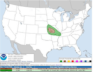
The Storm Prediction Center has much of Missouri in a marginal risk threat for severe weather today.  Many other areas are also included in this threat, as well as slight and enhanced risk areas (See graphic A).  This includes some risk for tornado development.  The MO Ozarks are within a 2% threat, but enough to at least be aware that there is a possibility (See graphic B).
The Springfield National Weather Service Forecast Office is expecting a significant flooding event to occur in the MO Ozarks today.  This flooding event could exceed the flooding of 2008 and 2011. In addition, The following risks are expected today:
  • Limited tornado risk
  • Limited hail risk
  • Limited thunderstorm wind damage risk
  • Significant flooding risk
  • Limited lightning risk
  • Graphic B.  SPC Tornado Outlook 12/26/15
  • Limited non-thunderstorm wind risk
You should stay tuned to local weather forecasts, as the information at OzarkStorms.com is only current at the time of posting and may not be all inclusive.  Make sure your NOAA All Hazards Radio is on and backed up by battery. If you don't own a NOAA All Hazards Radio, you should. Click the link for a previous blog post on selecting one.


Springfield, MO NWS - Hazardous Weather Outlook


Significant Flooding Event Likely

The NWS is forecasting 5 to 8 inches of rain in the area, and a significant flooding event is expected.  It is possible this could exceed the flooding in 2008 and 2011.  Please pay attention to flood prone areas, and avoid trying to cross flowing water.  Turn around, don't drown.  Please vising the Springfield, MO NWS site (or your assigned office) to stay informed.


Tuesday, November 17, 2015

Severe Weather Threat Today

SPC Convective Outlook
The Storm Prediction Center has a portion of the area in a slight risk box today. Additionally, at the time of this posting there is a Severe Thunderstorm Watch until noon for a portion of the Ozarks. There is also an active Tornado Warning for Southeastern Dade and Northwestern Greene counties, expiring at 6:45AM.

The National Weather Service lists the potential threats as:
  • Limited tornado risk
  • Limited to Elevated thunderstorm wind damage risk
  • Elevated flooding risk
  • Limited lightning risk
  • Limited non-thunderstorm wind risk

You should stay tuned to local weather forecasts, as the information at OzarkStorms.com is only current at the time of posting and may not be all inclusive.  Make sure your NOAA All Hazards Radio is on and backed up by battery. If you don't own a NOAA All Hazards Radio, you should. Click the link for a previous blog post on selecting one.

Springfield, MO NWS - Hazardous Weather Outlook


Wednesday, November 11, 2015

Severe Weather Risk Today: UPDATED

UPDATED 11:12AM

SPC Tornado Probability
The Storm Prediction Center (SPC) shows all of MO in some risk for tornado development along with other areas.  In the picture to the right from the SPC, the areas in green are a 2% risk of tornado development within 25 miles of any point, and the brown area is a 5% risk of the same.
The National Weather Service Forecast Office in Springfield, MO lists the risks for today as:
  • Limited tornado risk
  • Elevated thunderstorm wind damage risk
  • Elevated lightning risk
  • Significant non-thunderstorm wind damage risk
  • Significant fire weather risk
SPC Sever Weather Risk
Please note the picture above is filtered on tornado risk only.  The picture on the lower right is overall severe weather risks today.

You should stay tuned to local weather forecasts, as the information at OzarkStorms.com is only current at the time of posting.  Make sure your NOAA All Hazards Radio is on and backed up by battery. If you don't own a NOAA All Hazards Radio, you should. Click the link for a previous blog post on selecting one.

Springfield, MO NWS - Hazardous Weather Outlook


Tuesday, November 10, 2015

Severe Weather Possible Wed 11/11/15

National Weather Service - Springfield, MO
The Storm Prediction Center has shifted the enhanced risk for severe weather on Wednesday 11/11/15 more to the  north into Central Missouri, and parts of IL and IA.  This leaves the SW MO area in a slight risk area for severe weather development.  This does NOT rule out the possibility of tornado development, but it does indicate a reduced threat.

The National Weather Service office in Springfield reports that storms should begin firing between 10AM and 12PM in SE KS and Western MO, with storms making it to the Springfield, MO area between 2PM and 4PM. Please plan accordingly.

You should stay tuned to local weather forecasts, as the information at OzarkStorms.com is only current at the time of posting.  Make sure your NOAA All Hazards Radio is on and backed up by battery. If you don't own a NOAA All Hazards Radio, you should. Click the link for a previous blog post on selecting one.

Springfield, MO NWS - Hazardous Weather Outlook


Monday, November 9, 2015

SPC Convective Outlooks and "Risk"

When posting strong or severe storm updates, we will often note that the Storm Prediction Center has defined a "risk box" for severe weather.  The Storm Prediction Center (SPC) is responsible for providing watches for severe thunderstorms and tornadoes within the United States, and is part of the National Weather Service (NWS) and the National Centers for Environmental Prediction.  Warnings are issued by local NWS Forecast Offices.  A"risk box" is a term we use for an area of forecast by SPC for severe weather, and can be defined in five categories. Typically the language we use is something like "The Storm Prediction Center has the area in a slight risk box...".  These risks are color coded on a map, and are defined as:

Marginal - limited organization and longevity, or very low coverage and marginal intensity

Slight - organized severe thunderstorms are expected, but usually in low coverage with varying levels of intensity

Enhanced - greater concentration of organized severe thunderstorms with varying levels of intensity.

Moderate - indicates potential for widespread severe weather with several tornadoes and/or numerous severe thunderstorms, some of which may be intense. 

High - severe weather outbreak is expected from either numerous intense and long-track tornadoes, or a long-lived derecho system with hurricane-force wind gusts producing widespread damage. 

The SPC creates Convective Outlooks for Day 1 (today) through Day 8.  The accuracy and certainty is greater on Day 1, than on Day 3 for example.  Regardless, these products are great for awareness and preparation.

Thursday, November 5, 2015

Severe Storm Potential for 11/5/2015

Storm Prediction Center - Tornado Risk
All of Missouri, Arkansas, most of Oklahoma and the Eastern half of Kansas have a marginal risk for severe weather today.  The National Weather Service in Springfield expects severe weather to move into Eastern Kansas later today. If instability in the atmosphere develops this afternoon, all modes of severe weather will be possible, including a limited risk for tornado development. While this isn't a severe weather outbreak situation, there is some possibility, so please remain aware of the potential.

The NWS in Springfield lists the risks as:
  • Limited tornado risk
  • Limited hail risk
  • Limited thunderstorm wind risk damage
  • Significant lighting risk
You should stay tuned to local weather forecasts, as the information at OzarkStorms.com is only current at the time of posting.  Make sure your NOAA All Hazards Radio is on and backed up by battery. If you don't own a NOAA All Hazards Radio, you should. Click the link for a previous blog post on selecting one.

Springfield, MO NWS - Hazardous Weather Outlook


Tuesday, August 18, 2015

Risk of Severe Weather Today

The Storm Prediction Center has areas of the Ozarks in a 2% tornado threat, along with other severe weather threats.  The National Weather Service office in Springfield lists the risks as:
  • Elevated hail risk
  • Elevated thunderstorm wind damage risk
  • Elevated to significant lighting risk
You should stay tuned to local weather forecasts, as the information at OzarkStorms.com is only current at the time of posting.  Make sure your NOAA All Hazards Radio is on and backed up by battery. If you don't own a NOAA All Hazards Radio, you should. Click the link for a previous blog post on selecting one.

Springfield, MO NWS - Hazardous Weather Outlook


Wednesday, August 5, 2015

Severe Weather Potential Later Today


UPDATE 12:54PM:  SPC and NWS have updated the forecast and removed the potential for severe weather in most of these areas.

The Storm Prediction Center has portions of SW MO, SE KS, NE OK and NW AR in a slight risk for severe weather today. The National Weather Service in Springfield, MO notes that once the storms clear this morning, if the atmosphere recovers, the main concern will be the potential for severe weather later this afternoon.  The main risks will be:
  • Limited tornado risk
  • Elevated hail risk
  • Elevated thunderstorm wind damage risk
  • Elevated flooding risk
  • Significant lightning risk
  • Limited excessive heat risk
You should stay tuned to local weather forecasts, as the information at OzarkStorms.com is only current at the time of posting.  Make sure your NOAA All Hazards Radio is on and backed up by battery. If you don't own a NOAA All Hazards Radio, you should. Click the link for a previous blog post on selecting one.

Springfield, MO NWS - Hazardous Weather Outlook


Wednesday, July 1, 2015

Severe Weather Possible Tonight/Tomorrow

The Storm Prediction Center has much of MO and other areas to the SE in a slight risk zone for
severe weather.  This includes the possibility of isolated tornadoes.  A good portion of MO is in a 5% risk area for that development.  The National Weather Service in Springfield, MO lists the hazards as:
  • Limited tornado risk
  • Elevated hail risk
  • Elevated thunderstorm wind damage risk
  • Significant flooding risk
  • Significant lighting risk
  • Limited excessive heat risk
Storms are expected to develop later this afternoon into the evening hours.  Severe weather is also possible Thursday afternoon and evening.

You should stay tuned to local weather forecasts, as the information at OzarkStorms.com is only current at the time of posting.  Make sure your NOAA All Hazards Radio is on and backed up by battery. If you don't own a NOAA All Hazards Radio, you should. Click the link for a previous blog post on selecting one.

Springfield, MO NWS - Hazardous Weather Outlook


Tuesday, June 30, 2015

Red morning sun? Canadian wildfires....

The wild fires in Canada provided a beautiful red sunrise this morning in Southwest Missouri.  Here's an interesting article that describes what is going on.

Friday, May 29, 2015

Severe Storms Possible This Evening In The Ozarks

The Storm Prediction Center has now (as of late this afternoon) put SW MO, SE KS, NE OK and
NW AR in a slight risk box, including a tornado risk.  The National Weather Service in Springfield, MO lists the potential risks in SW MO and SE KS as:
  • Elevated tornado risk
  • Limited hail risk
  • Limited thunderstorm wind damage risk
  • Elevated flooding risk
  • Significant lighting risk
There is currently a tornado warned storm in NE OK tracking towards SW MO.  

You should stay tuned to local weather forecasts, as the information at OzarkStorms.com is only current at the time of posting.  Make sure your NOAA All Hazards Radio is on and backed up by battery. If you don't own a NOAA All Hazards Radio, you should. Click the link for a previous blog post on selecting one.

Springfield, MO NWS - Hazardous Weather Outlook


Saturday, May 16, 2015

Severe Storms Expected Late This Evening


The Storm Prediction Center a portion of Western MO (including Joplin) in a slight risk area for severe weather, including a 2% chance of a tornado.  Further to the west there is an enhanced and moderate risk.  The National Weather Service office in Springfield, MO notes that severe storms could impact SE KS and SW MO later this evening, including a limited tornado risk.  The hazards expected are:
  • Limited tornado risk
  • Elevated hail risk
  • Elevated thunderstorm wind damage risk
  • Elevated flooding risk
  • Significant lightning risk
From roughly Joplin and to the west, the tornado risk is up to 5% with a 10% to 15% chance further west and into Central KS.

You should stay tuned to local weather forecasts, as the information at OzarkStorms.com is only current at the time of posting.  Make sure your NOAA All Hazards Radio is on and backed up by battery. If you don't own a NOAA All Hazards Radio, you should. Click the link for a previous blog post on selecting one.

Springfield, MO NWS - Hazardous Weather Outlook


Wednesday, April 8, 2015

Severe Weather Potential - Today and Tomorrow (4/8/15 - 4/9/15)


UPDATED 13:58
The Storm Prediction Center has most of the Midwest in a slight risk category for severe weather, and much of MO, KS and some of OK and IL in an enhanced risk for severe weather.  The National Weather Service in Springfield lists the following hazards:
  • Elevated tornado risk
  • Elevated hail risk
  • Elevated thunderstorm wind damage risk
  • Elevated Significant lightning risk
  • Limited non-thunderstorm wind risk
There will be a chance for daytime storms, however, the severe storms are expected to develop in the late afternoon west of MO, then move through the SW MO area.  

You should stay tuned to local weather forecasts, as the information at OzarkStorms.com is only current at the time of posting.  Make sure your NOAA All Hazards Radio is on and backed up by battery. If you don't own a NOAA All Hazards Radio, you should. Click the link for a previous blog post on selecting one.

Springfield, MO NWS - Hazardous Weather Outlook


Thursday, April 2, 2015

Severe Weather Potential Today - Thursday 4/2/15

The Storm Prediction Center has much of the Midwest in a slight risk box for severe weather, with an enhanced risk in extreme SE KS, extreme NE OK, Southern MO, extreme Northern AR and on to the east in small parts of IL, IN, KY, and TN.  The National Weather Service in Springfield lists the risks in the Ozarks as:
  • Elevated tornado risk  ***UPDATED***
  • Significant hail risk
  • Elevated thunderstorm wind damage risk
  • Elevated flooding risk
  • Significant lightning risk
The potential for severe weather will be late afternoon into tonight.
  
You should stay tuned to local weather forecasts, as the information at OzarkStorms.com is only current at the time of posting.  Make sure your NOAA All Hazards Radio is on and backed up by battery. If you don't own a NOAA All Hazards Radio, you should. Click the link for a previous blog post on selecting one.

Springfield, MO NWS - Hazardous Weather Outlook


Wednesday, March 25, 2015

Severe Storms Likely Later Today (Wed 3/25/15)

The Storm Prediction Center has a good portion of OK and the far SW portion of MO in a moderate risk box for severe weather today.  The Springfield NWS Office lists the primary risk being ping pong ball sized hail for SW MO.  The full list includes:
  • Limited tornado risk
  • Elevated to significant hail risk
  • Elevated thunderstorm wind damage risk
  • Elevated flooding risk
  • Significant lighting risk
  • Limited non-thunderstorm wind risk
You should stay tuned to local weather forecasts, as the information at OzarkStorms.com is only current at the time of posting.  Make sure your NOAA All Hazards Radio is on and backed up by battery. If you don't own a NOAA All Hazards Radio, you should. Click the link for a previous blog post on selecting one.

Springfield, MO NWS - Hazardous Weather Outlook


Tuesday, March 24, 2015

Severe Thunderstorms Today (Tuesday 3/24/15)

There is an enhanced risk for severe weather in SW MO today, with some risk also in SE KS, NE OK, and NW AR.  The National Weather Service in Springfield, MO lists the risks as:
  • Limited tornado risk
  • Elevated hail risk
  • Limited thunderstorm wind damage risk
  • Elevated lighting risk
  • Limited non thunderstorm wind risk
The main threat will be large hail, and the timing is expected to be later this afternoon and into the evening.

You should stay tuned to local weather forecasts, as the information at OzarkStorms.com is only current at the time of posting.  Make sure your NOAA All Hazards Radio is on and backed up by battery. If you don't own a NOAA All Hazards Radio, you should. Click the link for a previous blog post on selecting one.

Springfield, MO NWS - Hazardous Weather Outlook


Monday, March 23, 2015

Severe Weather Possible Tuesday and Wednesday 3/24-3/25 2015

It's that time of year again.  Now is the time to prepare for Spring weather.  Do you have a safety plan?  Do you have an all hazards radio (weather alert)?  How about sheltering supplies?  If you wait until there is a weather event, then it isn't a plan any more...it's a reaction.

Initial statements indicate large hail will be the main threat on Tuesday and Wednesday.  More to follow...

You should stay tuned to local weather forecasts. Make sure your NOAA All Hazards Radio is on and backed up by battery. If you don't own a NOAA All Hazards Radio, you should. Click the link for a previous blog post on selecting one.

Springfield, MO NWS - Hazardous Weather Outlook


Monday, March 9, 2015

Outlaw Chasers - Funnelcide! **Language Alert**

If you want to watch high intensity storm chasing without fluff and drama, this should do the trick.  This kind of thing is not for the amateur.  I don't even suggest it for the pro.  But it is intense.  Randy is a big boy, and can do things how he wishes...and that he does!  ***Language Alert***