Monday, June 27, 2011

Strong to Severe Storms Expected Later Today - 6/27/11

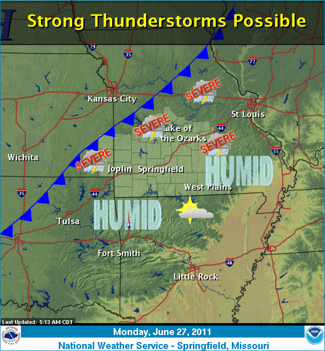
Strong to severe storms are likely to occur later today. An isolated tornado threat exists. Large hail and damaging winds are also possible The Springfield NWS Office lists the threats as:
  • Tornado Risk: Limited
  • Hail Risk: Elevated
  • T-Storm Wind Risk: Elevated
  • Lightning Risk: Elevated
  • Non T-Storm Wind Risk: Limited
  • Flooding Risk: Limited
  • Heat Risk: Limited
You should stay tuned to local weather forecasts. Make sure your NOAA All Hazards Radio is on and backed up by battery. If you don't own a NOAA All Hazards Radio, you should. Click the link for a previous blog post on selecting one.


Tuesday, June 21, 2011

Amazing Tornado Video From Nebraska - June 20, 2011

This video is from the same group that captured video of the Joplin, MO tornado on May 22, 2011 from it's inception. Hopefully these groups are reporting in what they are seeing so it will give a heightened level of warning to the public. This is amazing footage.

Please folks, if you are under a tornado warning, please take it seriously...

Monday, June 20, 2011

Strong to Severe Storms Likely Tonight - 6/20/11

Strong to severe storms are likely to occur this evening into tonight. An isolated tornado threat exists be west of the Highway 71 corridor. Large hail and damaging winds are possible west of the Highway 65 corridor. The Springfield NWS Office lists the threats as:
  • Tornado Risk: Limited
  • Hail Risk: Elevated
  • T-Storm Wind Risk: Elevated
  • Lightning Risk: Elevated
  • Non T-Storm Wind Risk: Elevated
  • Heat Risk: Limited
Severe storms will be possible on Tuesday as well.

You should stay tuned to local weather forecasts. Make sure your NOAA All Hazards Radio is on and backed up by battery. If you don't own a NOAA All Hazards Radio, you should. Click the link for a previous blog post on selecting one.


Saturday, June 18, 2011

Severe Storms Expected Late This Afternoon and Evening

The NWS has issued a Severe Thunderstorm Watch for portions of Western MO and Eastern KS

The Storm Prediction Center has much of the mid section of the country, including the Ozarks, in a slight risk box for severe weather. The Springfield National Weather Service expects thunderstorms to develop across the Ozarks today, initially taking on super cellular structure for a short period of time. Damaging winds up to 70MPH and hail the size of quarters will be the biggest threat, although an isolated tornado is possible.

Today's risks include:
  • Tornado Risk: Limited
  • Large Hail Risk: Elevated
  • T-Storm Wind Risk: Elevated
  • Lightning Risk: Elevated
  • Non T-Storm Wind Risk: Limited
  • Heat Risk: Limited
You should stay tuned to local weather forecasts. Make sure your NOAA All Hazards Radio is on and backed up by battery. If you don't own a NOAA All Hazards Radio, you should. Click the link for a previous blog post on selecting one.


Friday, June 17, 2011

Strong to Severe Storms Late Today - 6/17/11

Strong to severe storms may develop over the Ozarks late this afternoon into the evening. The Storm Prediction Center has our area listed in a slight risk box. The National Weather Service office in Springfield is calling for the biggest chance being north of I-44. Tomorrow there is another chance for severe weather including a chance for isolated tornadoes.

Today's risks include:
  • Tornado Risk: Limited
  • Large Hail Risk: Elevated
  • T-Storm Wind Risk: Elevated
  • Lightning Risk: Elevated
  • Non T-Storm Wind Risk: Limited
You should stay tuned to local weather forecasts. Make sure your NOAA All Hazards Radio is on and backed up by battery. If you don't own a NOAA All Hazards Radio, you should. Click the link for a previous blog post on selecting one.


Thursday, June 16, 2011

Severe Storms Possible Today - 6/16/11

The Storm Prediction Center has almost all of MO, SE KS, NE OK and NW AR in a slight risk box today. The Springfield NWS Office Hazardous Weather Outlook calls for scattered storms to move southeast into the area today. Severe weather potential starts late this morning. There is some uncertainty as to how and where the storms will form.

The risks include:
  • Tornado Risk: Limited
  • Large Hail Risk: Elevated
  • T-Storm Wind Risk: Elevated
  • Lightning Risk: Elevated
  • Excessive Heat Risk: Limited
You should stay tuned to local weather forecasts. Make sure your NOAA All Hazards Radio is on and backed up by battery. If you don't own a NOAA All Hazards Radio, you should. Click the link for a previous blog post on selecting one.


Wednesday, June 15, 2011

Tuesday, June 14, 2011

Severe Weather Risk Late This Afternoon and Tonight

The Storm Prediction Center has all of MO, SE KS, NE OK and NW AR in a slight risk box today. The Springfield NWS Office Hazardous Weather Outlook calls for widely scattered storms today with a hail possibility. Severe weather potential starts late this afternoon and tonight. The risks include:
  • Tornado Risk: Limited
  • Hail Risk: Elevated
  • T-Storm Wind Risk: Elevated
  • Lightning Risk: Elevated
  • Non T-Storm Wind Risk: Limited
  • Excessive Heat Risk: Limited
You should stay tuned to local weather forecasts. Make sure your NOAA All Hazards Radio is on and backed up by battery. If you don't own a NOAA All Hazards Radio, you should. Click the link for a previous blog post on selecting one.


Friday, June 10, 2011

Severe Thunderstorm Watch Until Midnight


Stay alert this evening for rapidly changing weather conditions.


You should stay tuned to local weather forecasts. Make sure your NOAA All Hazards Radio is on and backed up by battery. If you don't own a NOAA All Hazards Radio, you should. Click the link for a previous blog post on selecting one.

Strong To Severe Storms Possible Today - 6/10/11

Strong to severe storms are possible late this afternoon and evening in the Ozarks. This will mainly impact along and north of I-44. The hazards expected, as noted by the National Weather Service, are:

  • Hail Risk - Elevated
  • Wind Risk - Elevated
  • Lightning Risk - Elevated
  • Flash Flood Risk - Limited
You should stay tuned to local weather forecasts. Make sure your NOAA All Hazards Radio is on and backed up by battery. If you don't own a NOAA All Hazards Radio, you should. Click the link for a previous blog post on selecting one.

Wednesday, June 8, 2011

Christian County CERT

Those of you who know me, know that I am very proud to be CERT trained and affiliated with the Christian County CERT group. I want to do more, but I am glad to have been able to go down to Joplin and help in some way. Here is a News Leader article explaining what it is that our team did to help out in Joplin, MO.

Tuesday, June 7, 2011

Emergency Services Audio From Joplin MO Tornado 5/22/11

This thirty six minute audio is from Jasper County emergency services during and after the tornado went through town.

Monday, June 6, 2011

Joplin MO Tornado Footage - Before, During and After

Video from before, during and after the EF-5 tornado ripped through Joplin, MO on May 22, 2011. Please understand, many more lives are saved when spotters report in and people know there is a tornado on the ground. Jeff and Kathryn Piotrowski were on this storm and repeatedly called in warnings and begged law enforcement to sound the sirens. This is heartbreaking...

3D Animation of Joplin, MO EF-5 Multi-Vortex Tornado on May 22, 2011

The National Climatic Data Center has posted an article on Spring 2011 climate extremes. It contains good information on the May 22, 2011 Joplin, MO EF-5 tornado. An AMAZING video with a 3D breakdown of the Joplin multi-vortex tornado is included.

This is easily the most incredible weather related forensic graphic I have ever seen!

God bless Joplin.