Wednesday, December 19, 2012

Strong to Severe Storms Expected This Evening

Strong to severe storms are expected to develop this evening in the Ozarks.  The Storm Prediction Center has a slight risk box covering the bottom half of MO, through AR and down to the Gulf of Mexico.  The National Weather Service office in Springfield, MO list the threats to include:
  • Limited tornado risk
  • Elevated thunderstorm wind damage risk
  • Significant lightning risk
  • Elevated non-thunderstorm wind risk
You should stay tuned to local weather forecasts. Make sure your NOAA All Hazards Radio is on and backed up by battery. If you don't own a NOAA All Hazards Radio, you should. Click the link for a previous blog post on selecting one.


Tuesday, December 11, 2012

12/10/12 Edgewater, FL Tornado Footage

This is really close up and clear footage of a tornado crossing in front of a vehicle in Edgewater, FL on 12/10/12.

Sunday, December 9, 2012

Tornado Watch - SE MO and parts of IL, AR, KY and TN

The Storm Prediction Center has issued a Tornado Watch for SE MO, and parts of AR, IL, KY and TN until 9PM CT.  We are very close to breaking a new record for the longest period of time between deadly tornadoes, I hope people are paying attention, and we can break that record.  Arkansas already has tornado warnings issued at the time of this article.

Tuesday, December 4, 2012

Probability Of Slight, Moderate and High Risk

Hey there folks, it's been a while.  Thankfully 2012 has been a pretty quiet severe weather year for the most part.  With many of our severe weather posts, you'll see us make note of the Storm Prediction Center risk box, which is part of their Convective Outlook forecast.  In this article at Tornado Titans, they have written about the daily risk probability videos put together by Patrick Marsh.

It's pretty interesting stuff for a weather weenie.

Wednesday, October 17, 2012

Strong to Severe Storms Possible Today

Strong to severe storms are possible today.  The Storm Prediction Center has a large portion of MO in a slight risk box for severe weather today, including other states to the east and south.  The National Weather Service in Springfield, MO lists the risks today as:
  • Limited tornado risk
  • Elevated hail risk
  • Elevated thunderstorm wind damage risk 
  • Significant lightning risk
  • Limited non-thunderstorm wind risk
There are storms already developing in the Joplin, MO area, and areas to the north and south of that location.  The Storm Prediction Center is considering a weather watch for the Ozarks at the time of this post.

You should stay tuned to local weather forecasts. Make sure your NOAA All Hazards Radio is on and backed up by battery. If you don't own a NOAA All Hazards Radio, you should. Click the link for a previous blog post on selecting one.


Sunday, October 14, 2012

Confirmed Willard Tornado - 10/13/12

At brief EF-0 tornado with winds estimated up to 80 MPH touched down in a rural neighborhood on the SW side of Willard at 8:53 PM on Saturday 10/13/12.  There were no injuries and no serious damage.  Several trees and large limbs were blown down in all directions.  Several homes had minor damage to siding and roofs.  A wooden deck was lifted off the ground and moved from it's original position.  The path was 100 yards wide and about 1/2 mile long.

We were positioned a few miles to the SE at MM and I-44 and had my eyes on this storm, but with the lack of lightning, it was impossible to identify any storm structure.  We did head into Willard after the storm but failed to find any damage, although other spotters did find some confirmed damage in that area.  I will post more information as it becomes available.

Saturday, October 13, 2012

Strong to Severe Storms Late Today and Tonight

The Storm Prediction Center is calling for a slight risk for severe weather over much of MO, KS, OK and NW AR (as well as other portions of the Midwest).  The National Weather Service is forecasting strong to severe storms to move into the western potions of the forecast area (eastern KS counties and western MO counties) late this afternoon and move through the rest of the area through the night time hours.  Damaging wind gusts of 75mph will be the primary risk with these storms.  The list of risks include:
  • Limited tornado risk
  • Elevated hail risk
  • Elevated thunderstorm wind damage risk
  • Significant lightning risk
You should stay tuned to local weather forecasts. Make sure your NOAA All Hazards Radio is on and backed up by battery. If you don't own a NOAA All Hazards Radio, you should. Click the link for a previous blog post on selecting one.


Thursday, October 11, 2012

Chance For Strong to Severe Storms Tonight

National Weather Service
Thunderstorms are expected to develop later today into the evening and overnight hours.  The main risk at this time is hail and lightning.

*** More severe weather is expected Saturday***

You should stay tuned to local weather forecasts. Make sure your NOAA All Hazards Radio is on and backed up by battery. If you don't own a NOAA All Hazards Radio, you should. Click the link for a previous blog post on selecting one.


Friday, September 7, 2012

Strong to Severe Storms Today

The National Weather Service reports strong to severe storms will move into SW MO after 1pm today.  Large hail up to half dollar size, damaging wind gusts and lightning are the main threats.  These storms should move out of the eastern Ozarks by 7pm.  The Storm Prediction Center is not showing a tornado risk with these storms, but as always, keep informed.  The threats are listed as:

  • Elevated hail risk
  • Elevated thunderstorm wind damage risk
  • Significant lightning risk

You should stay tuned to local weather forecasts. Make sure your NOAA All Hazards Radio is on and backed up by battery. If you don't own a NOAA All Hazards Radio, you should. Click the link for a previous blog post on selecting one.


Thursday, September 6, 2012

Strong to Severe Storms Possible Today Into Friday

Strong to severe storms will be possible today into Friday in SW MO.  The main threats will be large hail and lightning.  The National Weather Services notes the following risks:
  • Limited hail risk
  • Limited thunderstorm wind damage risk
  • Elevated lightning risk
  • Elevated extreme heat risk
You should stay tuned to local weather forecasts. Make sure your NOAA All Hazards Radio is on and backed up by battery. If you don't own a NOAA All Hazards Radio, you should. Click the link for a previous blog post on selecting one.


Thursday, August 30, 2012

Remnants of Isaac to Bring Much Needed Rain - Just Not Enough

Hurricane Isaac on August 28, 2012
The remnants of Hurricane Isaac will impact the Ozarks Rain after midnight tonight, and linger throughout Saturday.  The latest information is that the Ozarks may see only two to five inches as a result.  We are much further into a drought than two to five inches.  Regardless, it will be welcome and much needed rain.  There is still a possibility for heavier rain, and with the condition of the soil, it could lead to flash flooding.

The National Weather Service has great information on Isaac, and the impact to the Ozarks. With a system like this, there is a chance for isolated severe weather and high wind gusts.  You should stay tuned to local weather forecasts. Make sure your NOAA All Hazards Radio is on and backed up by battery. If you don't own a NOAA All Hazards Radio, you should. Click the link for a previous blog post on selecting one.


Thursday, August 16, 2012

Strong Storms Possible Later Today

The Storm Prediction Center has large portions of MO and OK, and a small portion of SE KS in a slight risk box for severe weather, along with several other states to the NE of the Ozarks.  The Springfield National Weather Service office is forecasting general storms today, but the possibility of stronger storms later this afternoon and evening.  The main risks include:
  • Elevated hail risk
  • Elevated thunderstorm wind damage risk
  • Elevated lightning risk
  • Limited excessive heat risk
We can expect the possibility of damaging straight line winds over 60MPH and hail to the size of quarters.


You should stay tuned to local weather forecasts. Make sure your NOAA All Hazards Radio is on and backed up by battery. If you don't own a NOAA All Hazards Radio, you should. Click the link for a previous blog post on selecting one.


Sunday, August 12, 2012

Strong to Severe Storms Possible Today

The Storm Prediction Center has SW MO, extreme SE KS, eastern OK and NW AR in a slight risk box for severe weather, including a 2% chance for tornado development.  The Springfield National Weather Service office in Springfield, MO lists the risks as:

  • Limited hail risk
  • Elevated thunderstorm wind damage risk
  • Limited lightning risk
  • Elevated fire weather risk
These storms are expected late this afternoon and evening, mainly after 5pm.

You should stay tuned to local weather forecasts. Make sure your NOAA All Hazards Radio is on and backed up by battery. If you don't own a NOAA All Hazards Radio, you should. Click the link for a previous blog post on selecting one.


Wednesday, August 8, 2012

Strong to Severe Storms Possible Tonight

Scattered strong to severe storms will be possible this afternoon and evening according to the National Weather Service in Springfield, MO.  The main threat will be straight line down burst winds and hail to one inch in diameter.

You should stay tuned to local weather forecasts. Make sure your NOAA All Hazards Radio is on and backed up by battery. If you don't own a NOAA All Hazards Radio, you should. Click the link for a previous blog post on selecting one.


Thursday, July 26, 2012

Strong to Severe Storms Today

This morning, isolated to scattered thunderstorms will be possible in SW MO.  Later this afternoon, scattered to numerous thunderstorms will develop, some of them will be strong to severe.  According to the National Weather Service in Springfield, MO the threats are listed as:
  • Limited hail risk
  • Elevated thunderstorm wind-damage risk
  • Elevated lightning risk
  • Elevated excessive heat risk
You should stay tuned to local weather forecasts. Make sure your NOAA All Hazards Radio is on and backed up by battery. If you don't own a NOAA All Hazards Radio, you should. Click the link for a previous blog post on selecting one.


Saturday, June 16, 2012

Strong to Severe Storms Possible Later Today

Strong to severe storms will be possible later this afternoon into this evening, according to the National Weather Service.  The best chance for severe storms will be along and north of the I-44 corridor.  The threats include:
  • Limited tornado risk
  • Elevated hail risk
  • Elevated thunderstorm wind damage risk
  • Limited lightning risk
  • Limited excessive heat risk
You should stay tuned to local weather forecasts. Make sure your NOAA All Hazards Radio is on and backed up by battery. If you don't own a NOAA All Hazards Radio, you should. Click the link for a previous blog post on selecting one.


Monday, June 11, 2012

Strong to Severe Storms Possible Today

An initial line of thunderstorms will move south into the area.  In the late morning to mid afternoon hours, thunderstorms are expected to redevelop and may reach strong to severe limits.  The National Weather Service office in Springfield lists the following risks expected:
  • Elevated hail risk
  • Elevated thunderstorm wind damage risk
  • Significant lightning risk
You should stay tuned to local weather forecasts. Make sure your NOAA All Hazards Radio is on and backed up by battery. If you don't own a NOAA All Hazards Radio, you should. Click the link for a previous blog post on selecting one.


Sunday, June 3, 2012

Severe Storms Possible Today

The Storm Prediction Center has much of OK, KS, AR and SW MO in a slight risk box for severe weather today.  The National Weather Service office in Springfield, MO lists the following hazards possible for SE KS and SW MO:
  • Limited tornado risk
  • Elevated hail risk
  • Elevated thunderstorm wind damage risk
  • Limited flooding risk
  • Elevated lightning risk
Scattered storms will move across the area this morning with the main risk being hail.  This afternoon and evening, severe storms are expected to develop.  Sufficient instability and wind shear will bring the risk of supercell development.  At this time, this is not a moderate or high risk situation.  But please pay attention to local forecasts as the weather scenario unfolds.

Make sure your NOAA All Hazards Radio is on and backed up by battery. If you don't own a NOAA All Hazards Radio, you should. Click the link for a previous blog post on selecting one.


Tuesday, May 29, 2012

Strong to Severe Storms Possible Tonight

The Storm Prediction Center has much of OK, Southern KS, and a small portion of SW MO in a slight risk box for severe weather.  The Hazardous Weather Outlook from the National Weather Service lists the possibility of strong to severe storms in eastern KS and OK this afternoon, then SW MO later tonight.  The risks are listed as:
  • Elevated hail risk
  • Elevated thunderstorm wind damage risk
  • Limited lightning risk
You should stay tuned to local weather forecasts. Make sure your NOAA All Hazards Radio is on and backed up by battery. If you don't own a NOAA All Hazards Radio, you should. Click the link for a previous blog post on selecting one.


Tuesday, May 22, 2012

One Year Ago - Joplin, MO

May 22, 2011

1:30 pm - the Storm Prediction Center issued a Tornado Watch that included the city of Joplin, MO.  

5:17 pm - the National Weather Services office in Springfield, MO issued a Tornado Warning that included the city of Joplin, MO.  

5:34 pm - a tornado started to develop just outside the city of Joplin, MO.

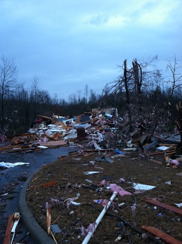
The rest of the timeline is burned into our memories.  We all know by now what happened in Joplin, MO and surrounding areas on May 22, 2011.  If nothing else comes out of this, I hope at the very least, it will convince people to be well prepared and pay attention to storm warnings.  If you  live in an area with a tornado risk, PLEASE use a Weather Alert Radio.

The National Weather Service has created a timeline graphic from this sad day.

They also have quite a bit of information in this Event Summary.

It's hard to believe it's been a year.  The magnitude of the Joplin tornado, and the unbelievable path it followed is still surreal.  I can't claim to know how it feels to lose a loved one or a home to a tornado.  I can tell you that my thoughts and prayers go out to those who have.

Monday, April 30, 2012

Severe Storms Tonight

A large portion of KS and OK, as well as SW MO are in a slight risk box for severe weather tonight.  This includes a tornado risk.  The National Weather Service in Springfield, MO lists the risks as:

  • Limited Tornado Risk
  • Elevated Hail Risk
  • Elevated Thunderstorm Wind Damage Risk
  • Elevated Flooding Risk
  • Significant Lightning Risk
As of this post, there have been tornado reports, and there are active tornado warnings.

You should stay tuned to local weather forecasts. Make sure your NOAA All Hazards Radio is on and backed up by battery. If you don't own a NOAA All Hazards Radio, you should. Click the link for a previous blog post on selecting one.


Sunday, April 29, 2012

Severe Storms Possible Today

The Storm Prediction Center has most of OK, SE KS and most of MO in a slight risk box for severe weather, with a small chance for tornadoes.  The Springfield NWS lists the risks as:

  • Elevated Hail Risk
  • Elevated Thunderstorm Wind Damage Risk
  • Limited Flooding Risk
  • Significant Lightning Risk
These threats will exist mainly through this morning and afternoon.

You should stay tuned to local weather forecasts. Make sure your NOAA All Hazards Radio is on and backed up by battery. If you don't own a NOAA All Hazards Radio, you should. Click the link for a previous blog post on selecting one.


1 Dead, 100 Hurt After Cardinals Game in St. Louis

Another incident where an outdoor event was not evacuated during a weather warning has occurred.  This time in St. Louis, MO after a Cardinals/Brewers game.  One person is dead, one hundred hurt, with five of them being critically injured.  When will even planners be held accountable for ignoring weather warnings?

Link to story

Friday, April 27, 2012

Strong to Severe Storms Possible Later Today

The Storm Prediction Center has NE OK, most of KS and Western MO in a slight risk box for severe weather.  Far central Western MO and the Eastern portion of central KS are in a moderate risk box.  The National Weather Service in Springfield, MO has listed the following risks for SW MO:
  • Elevated Tornado Risk
  • Significant Hail Risk
  • Elevated Thunderstorm Wind Damage Risk
  • Elevated Lightning Risk
  • Limited Non-Thunderstorm Wind Risk
You should stay tuned to local weather forecasts. Make sure your NOAA All Hazards Radio is on and backed up by battery. If you don't own a NOAA All Hazards Radio, you should. Click the link for a previous blog post on selecting one.


Sunday, April 15, 2012

Severe Weather Likely Today

The Storm Prediction Center has very far SE KS, E OK, AR and MO in a slight risk box for severe weather. Areas east of 65 are most likely to see any tornadic activity. The Springfield National Weather Service lists the risks as:
  • Limited tornado risk
  • Limited hail risk
  • Elevated thunderstorm wind damage risk
  • Limited flooding risk
  • Significant lightning risk
  • Elevated non-thunderstorm wind risk
The main threat appears to be east of highway 65 today. However, at the time of this blog post, there is currently a tornado warning in NE OK, that if it tracks into MO would track through parts of NW AR, then into Barry, Stone and Christian County. From what I can tell, this is not a current threat or concern for MO, I am only noting it to point out that tornadoes are still possible today in the Ozarks.

You should stay tuned to local weather forecasts. Make sure your NOAA All Hazards Radio is on and backed up by battery. If you don't own a NOAA All Hazards Radio, you should. Click the link for a previous blog post on selecting one.


Saturday, April 14, 2012

Severe Weather Threat For SW MO

The severe weather threat has spread further east into MO.   Sprinfield is now in the tornado threat area.  While it isn't in the outbreak area, there is some threat.  Please monitor local media.


KS, OK, NE and parts of MO and IA - Likely Tornadic Outbreak

There will likely be a tornadic outbreak in KS, OK, NE, far Western MO and Western IA today. Please plan now and stay tuned to local weather conditions. The image to the right is the tornado percentage for today. Chases will be out with a 5 to 10 percent chance. Please note the highest areas today are up to 45 percent. This is a serious situation, please be careful.

If you live in these areas, you should stay tuned to local weather forecasts. Make sure your NOAA All Hazards Radio is on and backed up by battery. If you don't own a NOAA All Hazards Radio, you should. Click the link for a previous blog post on selecting one.


Friday, April 13, 2012

Severe Weather Expected Through Sunday

The severe weather threat over the next three days is pretty widespread. Please pay attention to local forecasts. Today, the Storm Prediction Center has a large area of OK, KS and SW MO in a slight risk box. This includes the threat of tornadoes, especially in OK. The threat of severe weather in SW MO is later tonight into the overnight hours, and mainly west of Highway 71.

There will likely be a tornado outbreak in OK and KS on Saturday, conditions are really coming together. If you live in these areas, please pay close attention to local forecasts.

SW MO will likely have the biggest chance for severe weather on Sunday.

You should stay tuned to local weather forecasts. Make sure your NOAA All Hazards Radio is on and backed up by battery. If you don't own a NOAA All Hazards Radio, you should. Click the link for a previous blog post on selecting one.


Wednesday, March 28, 2012

Strong to Severe Storms Later Today

The Storm Prediction Center in Norman, OK has SW MO and SE KS (as well as a very small portion of NE OK and NW AR) in a slight risk box for severe weather today. Thunderstorms, some possibly severe, are expected to develop this afternoon and evening.
The National Weather Service in Springfield, MO lists the risk as follows:
  • Limited tornado risk
  • Elevated hail risk
  • Elevated thunderstorm wind damage risk
  • Elevated lightening risk
There is low confidence storms will develop this afternoon, but if they do, they will likely be strong to severe. This evening the confidence is higher that strong to severe storms will develop, with the main threat being hail to the size of quarters and wind gusts of 70MPH.

You should stay tuned to local weather forecasts. Make sure your NOAA All Hazards Radio is on and backed up by battery. If you don't own a NOAA All Hazards Radio, you should. Click the link for a previous blog post on selecting one.


Thursday, March 22, 2012

Strong Storms Today and Tonight

The National Weather Service in Springfield is forecasting thunderstorm development later today and into tonight. Some storms may include the following risks:
  • Limited tornado risk
  • Limited hail risk
  • Limited thunderstorm wind damage risk
  • Elevated flooding risk
  • Limited lightning risk
You should stay tuned to local weather forecasts. Make sure your NOAA All Hazards Radio is on and backed up by battery. If you don't own a NOAA All Hazards Radio, you should. Click the link for a previous blog post on selecting one.


Tuesday, March 20, 2012

Severe Weather Possible Today

The National Weather Service in Springfield notes that severe weather is possible today, but the probability is low. If severe weather develops, the following risks exist:
  • Significant flooding risk
  • Limited tornado risk
  • Limited thunderstorm wind damage risk
  • Significant lighting risk
  • Limited non thunderstorm wind risk
Periods of heavy rain are expected today and tonight, with an additional one to three inches today. Isolated severe storms with the above risks are possible, but due to limited instability the probability is low.

WATCH FOR FLOODING. TURN AROUND, DON'T DROWN.

You should stay tuned to local weather forecasts. Make sure your NOAA All Hazards Radio is on and backed up by battery. If you don't own a NOAA All Hazards Radio, you should. Click the link for a previous blog post on selecting one.


Monday, March 19, 2012

Severe Weather Possible Today - Flooding Likely Through Wed

The Storm Prediction Center in Norman, OK has most of MO, and half of AR, OK and KS in a slight risk box for severe weather. This includes a 5% risk of tornado development. Just for calibration sake, some areas are 2% today, and the moderate risk areas are at 10%. On outbreak days, that number can reach up in to the 30's or higher.

The National Weather Service in Springfield, MO lists today's severe weather risks as:
  • Limited tornado risk
  • Elevated hail risk
  • Elevated thunderstorm wind damage risk
  • Elevated flooding risk
  • Significant lightning risk
The big weather story is the four to eight inches of rain our area will be seeing through Wednesday. Flooding is likely. Please don't try to drive through flooded roads. Turn around, don't drown.

You should stay tuned to local weather forecasts. Make sure your NOAA All Hazards Radio is on and backed up by battery. If you don't own a NOAA All Hazards Radio, you should. Click the link for a previous blog post on selecting one.


Thursday, March 15, 2012

Tornado Warning Changes For Missouri And Kansas

Here is a great article from EarthSky.org about the upcoming changes to the tornado warning system in Missouri and Kansas. I tend to agree with the author, and others I've talked to, that I'm not sold that this will be a positive change. I feel like there is still enough ignorance about the difference between a watch and a warning, that three tiers of warnings may just confuse people more.

I agree a change is needed, the Joplin MO tornado proves that. Many people there flat out ignored the warning and the first siren, but took interest when the second tornado siren sounded. I feel that the biggest issue here is you can't care more about someone's safety than they do and affect it. I'm not so sure a "tornado warning" versus a "particularly dangerous situation tornado warning" is going to do any better reaching the target group.

I think my cynicism comes from the complacency a good percentage of the public has about severe weather, and their lack of accountability for personal safety. I hope I'm wrong, and this turns out to be a great improvement.

The bottom line is this: If there is a tornado warning for your area, there is a higher probability you will die if you don't do something to protect yourself. Also, it's not the tornado siren's job to keep you safe. It's your job to keep you safe. If you don't own a NOAA All Hazards Radio, you aren't doing enough to protect you and those around you.

Be safe.

Friday, March 9, 2012

Sunday, March 4, 2012

Why Storm Spotters/Chasers Should Be CERT Trained

On March 12, 2006 it became very obvious to my chase/spot partner (Jeff Kerr) and I that we should train for post disaster assistance. I even noted it in our log from that day. I did go on to receive that training, and feel better prepared for having it.

This video from two chasers out of Oklahoma really drives that point home. There are many reasons to become CERT trained. But two the biggest are:

1. Without the proper training, you may become part of the problem. Getting yourself hurt or killed will only complicate the recovery efforts, and reduce the attention the victims need. Emergency personnel don't need a bigger problem.

2. If you do come across a victim, you are going to want to help them. You can hurt them worse if you are not trained.

I highly recommend CERT training for everyone, even if you don't find yourself entering disaster areas. There are many skills learned that will help protect you and your family. And some day, hopefully never, you may really wish that you had this training to help during the aftermath of something like the May 22, 2011 Joplin, MO EF-5 tornado.

If you live in the Christian County area, there is a CERT training happening on Friday


If you live in the Christian County, MO area, there is a CERT training coming up on Friday/Saturday April 13th and 14th. This is a two day training. Friday night is 6:30pm to 9:30pm and Saturday is 8am to 4pm. It will be held at James River Assembly. If you are interested in receiving this FREE training, please call 417.581.2126. Tell them Jeff @ OzarkStorms.com sent you.

Friday, March 2, 2012

Severe Weather - March 2, 2012

While the Eastern Ozarks are still under the slight risk category for severe weather, the news today is further east. The Storm Prediction Center has issued a HIGH risk for severe weather for much of Kentucky and parts of Tennessee and Indiana. They are calling for a significant tornado episode, including large long tracked tornadoes.

I can't stop the weather, but I can sure do my best to convince people to take personal accountability and be prepared. When it comes down to it, we are all responsible for our own safety. Skip one meal out and buy a weather radio if you don't have one.

Please keep the folks in the danger zone in your thoughts and prayers today...

Make sure your NOAA All Hazards Radio is on and backed up by battery. If you don't own a NOAA All Hazards Radio, you should. Click the link for a previous blog post on selecting one.


Thursday, March 1, 2012

Severe Weather Possible Late Tonight/Early Friday

UPDATED
The National Weather Service in Springfield has noted in their Hazardous Weather Outlook that severe weather is possible in the Ozarks late tonight into early Friday. This includes some risk for tornadoes, especially in far southern MO. The risks include:
  • Limited Tornado Risk
  • Limited Non-Thunderstorm Wind Risk
  • Elevated Hail Risk
  • Limited Thunderstorm Wind Risk
  • Limited Lighting Risk
The Storm Prediction Center in Norman, OK has SW Mo in a 2% tornado probability risk. It's low, but worth noting.

You should stay tuned to local weather forecasts. Make sure your NOAA All Hazards Radio is on and backed up by battery. If you don't own a NOAA All Hazards Radio, you should. Click the link for a previous blog post on selecting one.


Wednesday, February 29, 2012

SW Missouri Leap Year Tornado Outbreak 2/28/12-2/29/12

The National Weather Service is putting together an event summary of the Leap Year 2012 tornado outbreak in Southwest Missouri. The information is still coming in, so keep checking back.

The video below is from 76 Highway right through the heart of Branson's entertainment district.


Please visit the OzarkStorms Facebook page for more information about this severe weather event.

Tornadoes Damage Multiple Areas Tues Night And Wed Morning

Multiple reports are coming in today of tornado damage in Lamar, Stockton, Buffalo, Lebanon, Branson (including the Branson Landing). Unfortunately at least one life was lost and multiple injuries are reported. Search and rescue operations are under way. I will post more when I have more information. Please keep our area in your prayers.

Update: I will post some informational updates updates on OzarkStorms.com website. I will post many more pictures and updates on the OzarkStorms Facebook Page.

Tuesday, February 28, 2012

Strong to Severe Storms This Evening - 2/28/12

The National Weather Service in Springfield, MO is forecasting strong to severe storms capable of producing golf ball sized hail, damaging winds and isolated tornadoes. These storms are expected this evening into the overnight hours.

While some storms will be possible late this afternoon, the storms of concern will follow with the main threats of:
  • Limited Tornado Risk
  • Elevated Hail Risk
  • Elevated Thunderstorm Wind Damage Risk
  • Significant Lightning Risk
  • Limited Non-Thunderstorm Wind Risk
The Storm Prediction Center in Norman, OK lists the tornado risk for the Ozarks at 5%.

You should stay tuned to local weather forecasts. Make sure your NOAA All Hazards Radio is on and backed up by battery. If you don't own a NOAA All Hazards Radio, you should. Click the link for a previous blog post on selecting one.


Monday, February 27, 2012

Severe Weather Possible On Tuesday 2/28/12

The Storm Prediction Center has the Ozarks in a slight risk box for severe weather tomorrow. More information will be available later today. This risk includes the possibility of tornadoes. The image to the right from KSPR shows the affected areas.

You should stay tuned to local weather forecasts.
Make sure your NOAA All Hazards Radio is on and backed up by battery. If you don't own a NOAA All Hazards Radio, you should. Click the link for a previous blog post on selecting one.


Thursday, February 23, 2012

Springfield NWS Dual Polarization Radar Upgrade

On February 17th the National Weather Service office in Springfield, MO completed their dual- polarization upgrade on the doppler radar. This new technology will result in 14 new radar products that will enable the NWS to continue providing the suite of high quality products and services to the public. This new technology and data will primarily help forecasters identify the type of precipitation that is falling as well as improve rainfall estimates.

For more information on dual-polarization technology:


Wednesday, February 22, 2012

Greene County, MO Weather Spotter Training - 2/28/2012

The Greene County MO spotter training from the National Weather Service is Tuesday, February 28th at 6:30 PM at the Assemblies of God HQ. The address is 1445 N Boonville Ave, Springfield, MO.

This training is not only for those who actively spot, but also for those who are interested. This year's training is quite a bit different than previous years, so I encourage a refresher for those who have attended before.

Monday, February 13, 2012

5/22/11 Joplin Tornado Video - 18 Wheeler


This is video shot from the dash of an 18 wheeler that was eastbound on I-44. The May 22, 2011 Joplin tornado moved northeast as it started through the city, but then took a southeast turn pretty quickly, and crossed over the interstate. It turned this semi over in the process. Watch it all the way through with sound. The roar of the tornado is very intense.

There are a few of things I would like for you to consider abou this video:
  1. Situational Awareness 1: It went from light of day to nighttime darkness in two minutes. If you are in this situation, turn on your radio to local media and make sure there isn't something horrible happening.
  2. Situational Awareness 2: If there are lines of cars on the side of the road stopped, they probably know something you don't. Pull over, and turn on the radio to find out what is going on. It appears this driver did finally pull over, but obviously it wasn't the best location to do so.
  3. This tornado was an EF-5 as it ripped through Joplin with winds over 200 MPH. It weakend to an EF-2/EF-3 as it went over I-44. So when it knocked this semi over, the winds were likely around 140 MPH. If this was the EF-5, there's a good chance this driver wouldn't have survived.
  4. There is no excuse in this day and age to not be alerted about severe weather. There are phone apps that will do the trick when you are mobile. If at home, please remember, no matter what time of year, have a NOAA All Hazards Radio ready to protect you and your family.
Storms can happen year round, but storm season is approaching. Take the time to get ready.

Saturday, February 4, 2012

Andy Gabrielson: We Lost One Of The Best.

It's a very sad day in the storm chaser community. Professional Storm Chaser Andy Gabrielson was killed in a head on collision in Oklahoma today, after a vehicle travelling the wrong way on I-44 struck his vehicle and others. If you've ever watched tornado footage on The Weather Channel, you have seen his work. It's been featured there quite a bit, as well as other major media outlets.


Andy was two weeks away from his 25th birthday, and leaves behind a three year old daughter. He was way too young to go. While I didn't know Andy personally, I've known of him for a couple of years, and started following his work closer it the last six months.

In the storm spotter presentation I have done a few times, and often in conversation, I tell people that the biggest risk storm spotting/chasing is the road, not the storm. This just really makes that hit home. Andy has been SO close to so many beasts...to go out like this is just sad. Especially if initial reports of a drunk driver going the wrong way is what happened.

Andy's family and friends are in my prayers.


Tuesday, January 24, 2012

Video From May 22, 2011 Joplin, MO Tornado


This is video from inside a chase tour van. It's really eerie to hear someone suggest taking cover at Home Depot at the 1:58 mark. My heart hurts thinking about what the folks in Joplin went through that day.

Monday, January 23, 2012

Tornadoes Have Devastated Parts of AR, MS, TN and AL

Aj2S2HqCIAIGWAj.jpg-large
During the evening and overnight hours of 1/22/12 and 1/23/12, tornadoes have ripped across parts of Arkansas, Tennessee, Mississippi and Alabama. Reports of damage and fatalities are still coming in. By the looks of some of these pictures, there were some strong tornadoes.

Please pray for the folks affected by these storms.

Please remember, no matter what time of year, have a NOAA All Hazards Radio ready to protect you and your family.

Thursday, January 19, 2012

NWS 2012 Spotter Training Calendar

The NWS Spotter Training Classes for 2012 have been posted. Please visit their website for the most up to date information for dates, times and locations. This training gets updated every year, so even if you've attended before, it's always a great refresher with some new information.