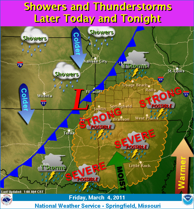
The National Weather Service in Springfield, MO is calling for the development of severe weather later today. Wind gusts of 60MPH and embedded tornadoes are possible with the line as it develops early this evening. The showers and thunderstorms during the early part of the day should remain below severe limits.
These risks later today include:
Limited tornado risk
Limited hail risk
Elevated thunderstorm wind damage risk
Elevated flooding risk
Significant lightning risk
** The Storm Prediction Center site appears to be down at this time. But the last indication was a slight risk box up through Arkansas and covering most of Missouri and eastern Kansas and Oklahoma.
You should stay tuned to local weather forecasts. Make sure your NOAA All Hazards Radio is on and backed up by battery. If you don't own a NOAA All Hazards Radio, you should. Click the link for a previous blog post on selecting one.
The Storm Prediction Center shows most of MO in a slight risk box for severe weather on Tuesday. The Springfield National Weather Service office lists the the primary threat being damaging straight line winds. Hail and an isolated weak tornadoes can not be ruled out.
You should stay tuned to local weather forecasts. Make sure your NOAA All Hazards Radio is on and backed up by battery. If you don't own a NOAA All Hazards Radio, you should. Click the link for a previous blog post on selecting one.
The Storm Prediction Center has most of MO and AR, SE KS and NE OK in a slight risk box for severe weather. The National Weather Service in Springfield, MO is forecasting that few strong to severe storms will be possible later today and tonight.
These risks include:
Elevated hail risk
Limited thunderstorm wind damage risk
Significant lightning risk
You should stay tuned to local weather forecasts. Make sure your NOAA All Hazards Radio is on and backed up by battery. If you don't own a NOAA All Hazards Radio, you should. Click the link for a previous blog post on selecting one.
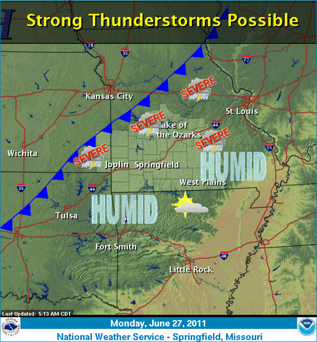
Severe thunderstorms are possible late this afternoon into tonight in SW MO, NW AR, NE OK and SE KS. The Springfield NWS lists the risks as:
Limited Tornado Risk
Elevated Hail Risk
Elevated Thunderstorm Wind Damage
Limited Flooding Risk
Significant Lighting Risk
A Severe Thunderstorm Watch is in effect for far SW MO until 11 p.m.
You should stay tuned to local weather forecasts. Make sure your NOAA All Hazards Radio is on and backed up by battery. If you don't own a NOAA All Hazards Radio, you should. Click the link for a previous blog post on selecting one.
The Storm Prediction Center has a portion of SW MO in a slight risk for severe weather overnight. The Springfield National Weather Service is calling for the possibility of 70 MPH winds, frequent lightning, hail to the size of quarters and heavy rains. The Springfield area can expect these storms in the early morning hours.
You should stay tuned to local weather forecasts. Make sure your NOAA All Hazards Radio is on and backed up by battery. If you don't own a NOAA All Hazards Radio, you should. Click the link for a previous blog post on selecting one.
This is video footage from Joplin High School security cameras from May 22, 2011 as the EF-5 tornado destroyed the school. Thank God this didn't hit during school hours!
I don't normally write about weather that doesn't include rain mixed with 100+ MPH winds, but this requires special attention. It's going to be hot. HOT. SW MO, SE KS, NE OK and NW AR are all under an Excessive Heat Warning until Wednesday. I expect it will extend after that. Temps will be 100+ for the next several days.
Take care of yourself, your loved ones, your neighbors and your pets! This is going to be dangerous to those exposed to the elements.
The Storm Prediction Center has Eastern KS and a large portion of MO in a slight risk box for severe weather. The Springfield National Weather Service office reports 60 MPH wind gusts and hail to the size of quarters is possible today.
The risks include:
Hail Risk: Limited
T-Storm Wind Risk: Limited
Lightning Risk: Elevated
Extreme Heat Risk: Elevated
You should stay tuned to local weather forecasts. Make sure your NOAA All Hazards Radio is on and backed up by battery. If you don't own a NOAA All Hazards Radio, you should. Click the link for a previous blog post on selecting one.
Strong to severe storms are likely to occur later today. An isolated tornado threat exists. Large hail and damaging winds are also possible The Springfield NWS Office lists the threats as:
Tornado Risk: Limited
Hail Risk: Elevated
T-Storm Wind Risk: Elevated
Lightning Risk: Elevated
Non T-Storm Wind Risk: Limited
Flooding Risk: Limited
Heat Risk: Limited
You should stay tuned to local weather forecasts. Make sure your NOAA All Hazards Radio is on and backed up by battery. If you don't own a NOAA All Hazards Radio, you should. Click the link for a previous blog post on selecting one.
This video is from the same group that captured video of the Joplin, MO tornado on May 22, 2011 from it's inception. Hopefully these groups are reporting in what they are seeing so it will give a heightened level of warning to the public. This is amazing footage.
Please folks, if you are under a tornado warning, please take it seriously...
Strong to severe storms are likely to occur this evening into tonight. An isolated tornado threat exists be west of the Highway 71 corridor. Large hail and damaging winds are possible west of the Highway 65 corridor. The Springfield NWS Office lists the threats as:
Tornado Risk: Limited
Hail Risk: Elevated
T-Storm Wind Risk: Elevated
Lightning Risk: Elevated
Non T-Storm Wind Risk: Elevated
Heat Risk: Limited
Severe storms will be possible on Tuesday as well.
You should stay tuned to local weather forecasts. Make sure your NOAA All Hazards Radio is on and backed up by battery. If you don't own a NOAA All Hazards Radio, you should. Click the link for a previous blog post on selecting one.
The NWS has issued a Severe Thunderstorm Watch for portions of Western MO and Eastern KS
The Storm Prediction Center has much of the mid section of the country, including the Ozarks, in a slight risk box for severe weather. The Springfield National Weather Service expects thunderstorms to develop across the Ozarks today, initially taking on super cellular structure for a short period of time. Damaging winds up to 70MPH and hail the size of quarters will be the biggest threat, although an isolated tornado is possible.
Today's risks include:
Tornado Risk: Limited
Large Hail Risk: Elevated
T-Storm Wind Risk: Elevated
Lightning Risk: Elevated
Non T-Storm Wind Risk: Limited
Heat Risk: Limited
You should stay tuned to local weather forecasts. Make sure your NOAA All Hazards Radio is on and backed up by battery. If you don't own a NOAA All Hazards Radio, you should. Click the link for a previous blog post on selecting one.
Strong to severe storms may develop over the Ozarks late this afternoon into the evening. The Storm Prediction Center has our area listed in a slight risk box. The National Weather Service office in Springfield is calling for the biggest chance being north of I-44. Tomorrow there is another chance for severe weather including a chance for isolated tornadoes.
Today's risks include:
Tornado Risk: Limited
Large Hail Risk: Elevated
T-Storm Wind Risk: Elevated
Lightning Risk: Elevated
Non T-Storm Wind Risk: Limited
You should stay tuned to local weather forecasts. Make sure your NOAA All Hazards Radio is on and backed up by battery. If you don't own a NOAA All Hazards Radio, you should. Click the link for a previous blog post on selecting one.
The Storm Prediction Center has almost all of MO, SE KS, NE OK and NW AR in a slight risk box today. The Springfield NWS Office Hazardous Weather Outlook calls for scattered storms to move southeast into the area today. Severe weather potential starts late this morning. There is some uncertainty as to how and where the storms will form.
The risks include:
Tornado Risk: Limited
Large Hail Risk: Elevated
T-Storm Wind Risk: Elevated
Lightning Risk: Elevated
Excessive Heat Risk: Limited
You should stay tuned to local weather forecasts. Make sure your NOAA All Hazards Radio is on and backed up by battery. If you don't own a NOAA All Hazards Radio, you should. Click the link for a previous blog post on selecting one.
The Storm Prediction Center has all of MO, SE KS, NE OK and NW AR in a slight risk box today. The Springfield NWS Office Hazardous Weather Outlook calls for widely scattered storms today with a hail possibility. Severe weather potential starts late this afternoon and tonight. The risks include:
Tornado Risk: Limited
Hail Risk: Elevated
T-Storm Wind Risk: Elevated
Lightning Risk: Elevated
Non T-Storm Wind Risk: Limited
Excessive Heat Risk: Limited
You should stay tuned to local weather forecasts. Make sure your NOAA All Hazards Radio is on and backed up by battery. If you don't own a NOAA All Hazards Radio, you should. Click the link for a previous blog post on selecting one.
Stay alert this evening for rapidly changing weather conditions.
You should stay tuned to local weather forecasts. Make sure your NOAA All Hazards Radio is on and backed up by battery. If you don't own a NOAA All Hazards Radio, you should. Click the link for a previous blog post on selecting one.
Strong to severe storms are possible late this afternoon and evening in the Ozarks. This will mainly impact along and north of I-44. The hazards expected, as noted by the National Weather Service, are:
Hail Risk - Elevated
Wind Risk - Elevated
Lightning Risk - Elevated
Flash Flood Risk - Limited
You should stay tuned to local weather forecasts. Make sure your NOAA All Hazards Radio is on and backed up by battery. If you don't own a NOAA All Hazards Radio, you should. Click the link for a previous blog post on selecting one.
Those of you who know me, know that I am very proud to be CERT trained and affiliated with the Christian County CERT group. I want to do more, but I am glad to have been able to go down to Joplin and help in some way. Here is a News Leader article explaining what it is that our team did to help out in Joplin, MO.
Video from before, during and after the EF-5 tornado ripped through Joplin, MO on May 22, 2011. Please understand, many more lives are saved when spotters report in and people know there is a tornado on the ground. Jeff and Kathryn Piotrowski were on this storm and repeatedly called in warnings and begged law enforcement to sound the sirens. This is heartbreaking...
In the midst of the "missing" list being posted, some good news has come out of Joplin, MO! The very first person on the list is ALIVE!!!! This according to ABC News!
"Sally Adams, 75, said neighbors rescued her Sunday after the storm destroyed her house and took her to a friend's home. When The Associated Press told Adams she was on the missing list, she laughed and said "Get me off of there!"
Here is a link to the New York Times story that has an interactive before and after slider with aerial photos from Joplin, MO. The photos showing damage from the May 22, 2011 tornado are heartbreaking. There is one big photo, and options at the top to pick specific areas.
You should stay tuned to local weather forecasts. Make sure your NOAA All Hazards Radio is on and backed up by battery. If you don't own a NOAA All Hazards Radio, you should. Click the link for a previous blog post on selecting one.
Another round of severe weather is expected to develop along the Highway 65 corridor and east. Areas Springfield and east are either in a slight risk or moderate risk box. The Springfield NWS office lists today's hazards as:
Elevated Tornado Risk
Elevated Significant Hail Risk
Elevated T-Storm Wind Damage Risk
Elevated Lightning Risk
Significant Flooding Risk
You should stay tuned to local weather forecasts. Make sure your NOAA All Hazards Radio is on and backed up by battery. If you don't own a NOAA All Hazards Radio, you should. Click the link for a previous blog post on selecting one.
There is a Tornado Watch until 3AM. This watch covers the western half of Missouri. Much of Arkansas, Kansas and Oklahoma are also under Tornado Watches.
You should stay tuned to local weather forecasts. Make sure your NOAA All Hazards Radio is on and backed up by battery. If you don't own a NOAA All Hazards Radio, you should. Click the link for a previous blog post on selecting one.
The tornado that ripped through Joplin has been upgraded to the largest Enhanced Fujita Scale rating of EF-5. The winds were above 200 MPH.
This is the deadliest tornado since modern record keeping started at the National Weather Service. It is now ranked as the 8th deadliest in history.
As of the evening of 5/24/11, 122 have been confirmed killed. About 1500 are missing, but due to communication issues, that number should come down quite a bit as people report in.
The Storm Prediction Center has the Ozarks in a moderate risk box, and From the Joplin, MO area west in a high risk box. It appears the tornado outbreak will be in the central Kansas and central Oklahoma areas. As these storms push eastward, some tornado development is still possible. According to the SPC, From Joplin west, there is a 30% probability of significant tornadoes to develop, eastward towards Springfield, that probability drops to 15%, which is still concerning.
This information WILL LIKELY change through the day, but right now it's looking like severe development around 4PM with it arriving in the western MO area between 6pm and exiting by Midnight.
You should stay tuned to local weather forecasts. Make sure your NOAA All Hazards Radio is on and backed up by battery. If you don't own a NOAA All Hazards Radio, you should. Click the link for a previous blog post on selecting one.
Strong to Severe storms are expected again today in the Ozarks. The Storm Prediction Center shows us in a slight risk box. The NWS Office in Springfield lists the risks as:
Elevated Tornado Risk
Significant Hail Risk
Elevated T-Storm Wind Risk
Elevated Flood Risk
Significant Lightning Risk
You should stay tuned to local weather forecasts. Make sure your NOAA All Hazards Radio is on and backed up by battery. If you don't own a NOAA All Hazards Radio, you should. Click the link for a previous blog post on selecting one.
Fresh on the heels of yesterday's tornado which impacted the Joplin area, the region is once again under a moderate risk of severe weather. Very large hail, damaging winds, and tornadoes will be possible in and near the areas above that are outlined in red. This includes all of the Missouri Ozarks.
Additionally, with the recent heavy rains coupled with the amounts forecasted over the next few days, there is a Flash Flood Watch for the region as well.
You should stay tuned to local weather forecasts. Make sure your NOAA All Hazards Radio is on and backed up by battery. If you don't own a NOAA All Hazards Radio, you should. Click the link for a previous blog post on selecting one.
The city of Joplin was pummeled by a very large tornado earlier this evening. The massive amounts of information that continue to stream in at this hour is so patchwork that it is hard to decipher facts from rumors. We is what I can confirm or let you know that local media is reporting:
* Nearly 75% of the community of over 40,000 was impacted by the storm.
* The city has been declared a local emergency disaster area by the mayor.
* The latest casualty number (and I urge that this will likely increase) is at 25 as of this blog post.
* St. John's Hospital was hard hit. The building was evacuated. Critically injured are being transported to Freeman Hospital, while the walking wounded were being advised to head to Memorial Hall. That triage location is full so McAuley High School has been opened to handle the overflow.
* All available medical help in the area is being urged to come to Joplin to assist. All others (including sightseers and gawkers) are urged to stay out!
* Joplin Public Schools will be closed tomorrow. The high school sustained a direct hit from the tornado.
There is the potential for severe weather tomorrow as well. The Storm Prediction Center has already issued a moderate risk for storms.
You should stay tuned to local weather forecasts. Make sure your NOAA All Hazards Radio is on and backed up by battery. If you don't own a NOAA All Hazards Radio, you should. Click the link for a previous blog post on selecting one.
Additional updates will be made to this blog as time permits. In the meantime, please check out The Joplin Globe and other local media outlets for the latest information.
If this story doesn't warm your heart, or maybe even bring a tear to your eye... I don't know what will. Not the fact she found her cat, but the fact that when she did, she felt like she had everything she cared about even though she lost her possessions in the storm. Bless her heart...
The Storm Prediction Center shows the western portion of the Ozarks in a slight risk box for severe weather today. Springfield is on the very eastern edge of this risk. The Springfield National Weather Service office lists the risks today as:
Tornado Risk: Limited
Hail Risk: Elevated
T-Storm Wind Damage Risk: Elevated
Lightning Risk: Significant
Flooding Risk: Limited
The best chance for severe weather will be this evening and into the overnight hours, mainly west of Highway 71.
You should stay tuned to local weather forecasts. Make sure your NOAA All Hazards Radio is on and backed up by battery. If you don't own a NOAA All Hazards Radio, you should. Click the link for a previous blog post on selecting one.
The Storm Prediction Center shows much of the Ozarks in a slight risk box for severe weather today. The Springfield National Weather Service lists the risks as:
Elevated Risk for Hail
Elevated Risk for Severe TStorm Winds
Elevated Risk for Lightning
Limited Risk for Tornadoes
Storms are likely to develop over the entire region this afternoon and evening.
You should stay tuned to local weather forecasts. Make sure your NOAA All Hazards Radio is on and backed up by battery. If you don't own a NOAA All Hazards Radio, you should. Click the link for a previous blog post on selecting one.
The Storm Prediction Center has SW MO, SE KS, NE OK and NW AR (and many other areas) in a slight risk box for severe weather, both today and tomorrow. According to the National Weather Service office in Springfield, MO, the risks include:
Elevated Risk for Hail
Elevated Risk for Severe TStorm Winds
Elevated Risk for Lightning
Limited Risk for Tornadoes
As of Wednesday afternoon, there is already a Severe Thunderstorm Watch until 10pm for a large area west of Springfield, MO.
You should stay tuned to local weather forecasts. Make sure your NOAA All Hazards Radio is on and backed up by battery. If you don't own a NOAA All Hazards Radio, you should. Click the link for a previous blog post on selecting one.
As a storm spotter, I have mixed emotions about this news story. I have to believe there is more to it than the media reported. Maybe there is a history of false reports, either by this spotter or others. But this brought two things to mind that I wanted to write about.
First, during every severe weather event, reports come in and reports are scrutinized. That's just how it works. There is a reason it is suggested that spotters pair up and get multiple views of storms. Different views of a storm can reveal different aspects.
A great example of this is the April 22, 2011 severe weather that came through the area. Jeff Kerr (KC0VGC) and I (KB0WVT) were on the south side of a tornado warned storm in Christian County. Between Nixa and Highlandville, we were right under the storm. At one point, there appeared to be a funnel. Jeff and I pulled over to give it a closer look and it was gone. We did not report a funnel, because we couldn't verify it. From our view, it was dark on dark, so it was hard to confirm. On the south side of the same storm, with the benefit of back lighting, Ron Hearst (KC0TCD), Chief Meteorologist at KY3, and his wife recorded video of the same storm. It is fairly clear in the video there is a funnel. Different eyes with a different perspective saw things in different light. Again, this is just how the system works.
Secondly, SkyWarn net control operators, and NWS, know many of the spotters. I think it's fair to say that the experience level of SkyWarn spotters and interactions with them tend to give those folks an idea of the credibility of the report. That's not meant to be a dig on new spotters at all, it's just with experience comes more accurate and meaningful reports.
With all of that being said, I think that this is far from news. What this TV station made into a news story happens all the time. Most of the time it's not intentional, it's just what may appear to be one thing to one person, may not be the case from a different view. I think there is a harmful side effect here if it means spotters are afraid to report what they are seeing until a building is being destroyed.
To any spotters out there, my best advice is just do what you are trained to do. Report what you see, and report what you don't see. Don't assume anything. If you think you see a funnel, but can't confirm rotation, then say that. If it looks like it's on the ground, but you don't debris, then say that. I personally like to have verification of my reports if at all possible.
What's more important than any of this, spotters, be safe and thank you for volunteering to help save life and property.
This is an image of the April 22, 2011 St. Louis tornado shot from Wentzville as the tornado moved eastward, just south of I-70. This image was sent to me by Scott Turner, and was taken by his brother Jeff Turner.
The National Oceanic and Atmospheric Administration (NOAA) has released their April 2011 tornado information. The data on the April 27, 2011-April 28, 2011 outbreak is horrific. You can read the report here. Here are a few statistics that are completely unbelievable. Please read the full report for more information.
266 tornadoes in a 24 hour period
Average lead time for tornado warnings: 24 minutes
90% of the tornadoes had tornado warning issued
344 fatalities from the outbreak, 334 of those in a 24 hour period
Two tornadoes from last Wednesday have been rated EF-5, with more possible. The Fujita Scale was introduced in 1971 by Ted Fujita, and for years was used as a measurement of the severity of a tornado. Many think the F rating was based on the size, or wind speed of a tornado. In reality, it is the damage that can be verified that in turn rates a Fujita rating, and correlates to estimated wind speed.
In 2006, the Enhanced Fujita Scale was implemented. The enhancement was using additional information such as construction methods, radar data, and damage to vegetation. For example the construction of a house constructed in 1950 may be structurally different than the wall from a house built this year, so the collapse of that wall could mean two completely different wind speeds.
The first EF-5 tornado (the highest rating) was the Greensburg, KS tornado in 2007. The second was in 2008 in Parkersburg, IA. The significance of this is that since 2006, there have only been two EF-5 tornadoes. On April 27, 2011 a major tornado outbreak hit the Southeast. While watching this event unfold, I predicted something I normally would not, simply based on real time information. I estimated we would end up seeing three to five EF-5 rated tornadoes once the damage was assessed. The radar signatures on these storms was off the charts, the areas affected were highly populated (more damage to assess), and the damage reports coming in were very, very severe.
To date, two tornadoes in this event have been rated EF-5, which is already rare. These are the Smithville, MS tornado and the Hackleburg, AL tornado. I would be surprised if we don't at least see the Tuscaloosa tornado end up EF-5. Considering there have been only two in five years, and there are already two confirmed in one day, this is quite a historic event.
I plan on posting soon about the death toll as well. As of this writing, there are 340 confirmed dead, which makes this the second worst tornado fatality event in our history. The only event that was worse was in 1925 where 695 people were killed. There are many reasons why these numbers are not apples to apples, and I would like to discuss that more later.
In all my years of observing severe weather, both locally and nationally, I have NEVER seen anything like what went on today, and is still going on. Mississippi, Alabama and Georgia and Tennessee have been hit HARD. At one time, there were 40 tornado warnings going on at once. The Weather Channel reported at 10:00pm that over 64 have been confirmed dead already.
Update: Death toll at 178, with128 of those in Alabama. Very sad.
Besides the number of tornadoes, I have never witnessed multiple large violent tornadoes going on at once in such a small part of the country.
Today is the 20th anniversary of the infamous Andover, KS tornado outbreak, which spawned 55 confirmed tornadoes, the most devastating being the F5 that decimated Andover, KS. In Andover, homes were swept from their foundations. You can read about it his outbreak here.
Here is a compilation video of tornadoes from that day.
This is the infamous overpass video, still talked about today. It is NOT safe to take shelter under an overpass! Notice about 1:12 into this video the van that is being tossed about, in and out of the ditch by the tornado. Very scary stuff...
The Storm Prediction Center has SW MO, NE OK and much of the country to the east in a slight risk box. Further south, there is a moderate and high risk box. A severe weather outbreak is expected in NE TX and Southern AR.
The National Weather Service in Springfield lists the risk in SW MO as:
Tornado risk: Limited
Flooding risk: Significant
Hail risk: Elevated
Thunderstorm wind damage: Elevated
Lightning risk: Elevated
The biggest threat will be the southern most counties in MO, especially south central MO.
You should stay tuned to local weather forecasts. Make sure your NOAA All Hazards Radio is on and backed up by battery. If you don't own a NOAA All Hazards Radio, you should. Click the link for a previous blog post on selecting one.
After a brief lull in the rain, the Ozarks can expect another storm system to impact the region this evening through tomorrow. As a result, the National Weather Service has extended the Flash Flood Watch through Wednesday afternoon for most of Southwest Missouri along and south of I-44.
Flooding is the biggest killer in the Ozarks. The region has numerous low water crossings and the terrain enhances the flash flooding potential.
For a look at the latest river levels across the region, please click here.
For road closures due to flooding, check out this link.
With the threat of more heavy rain later today: You should stay tuned to local weather forecasts. Make sure your NOAA All Hazards Radio is on and backed up by battery. If you don't own a NOAA All Hazards Radio, you should. Click the link for a previous blog post on selecting one.
Kevin Lighty from KSPR noted on Facebook tonight this amazing radar signature of a tornado near Vilonia, Arkansas. Both the storm relative velocity showing incredible rotation and the debris ball on the radar are just off the hook.
Reed Timmer is reporting that pavement has been scoured off near Vilonia. The last time I've hears about anything like that was the Jarrell, TX tornado in 1997, which was rated an F5.
Let's hope that the impact to the folks in Arkansas isn't as bad as it could be...
If you are in these areas, please pay special attention to local weather forecasts and warnings. A risk of strong, life threatening tornadoes exists in this area.
You should stay tuned to local weather forecasts. Make sure your NOAA All Hazards Radio is on and backed up by battery. If you don't own a NOAA All Hazards Radio, you should. Click the link for a previous blog post on selecting one.
The Storm Prediction Center has the Ozarks in a slight risk box for severe weather today. The good news is that the moderate risk box shifted south. The National Weather Service office in Springfield lists the following risks in the Hazardous Weather Outlook:
Flooding Risk: Significant to Extreme
Tornado Risk: Limited to Elevated
Lightning Risk: Significant
Hail Risk: Elevated
Thunderstorm Wind Risk: Limited to Elevated
These risks are most likely during the afternoon hours, and along and southeast of the Interstate 44 corridor.
You should stay tuned to local weather forecasts. Make sure your NOAA All Hazards Radio is on and backed up by battery. If you don't own a NOAA All Hazards Radio, you should. Click the link for a previous blog post on selecting one.
The NWS Office in St. Louis, MO has published a review of the Good Friday tornado that caused major damage to the Greater St. Louis Metropolitan area, including the Labert St. Louis International Airport.
The amazing thing is that there were no fatalities or reports of serious injury. Folks this tornado caused EF-4 damage (166-200MPH) at one point, and was rated EF-2 (111-135 MPH) when it hit the airport. With over 3o minutes of warning, and execution of safety plans, lives were saved. See this story from Fox News.
There is a continuing threat for severe weather in the area both overnight and on Monday. This threat includes the possibility of isolated tornadoes. Flooding is an issue due to the continuing rainfall. Please be safe at low water crossings, etc. Turn around, don't drown!
You should stay tuned to local weather forecasts. Make sure your NOAA All Hazards Radio is on and backed up by battery. If you don't own a NOAA All Hazards Radio, you should. Click the link for a previous blog post on selecting one.
You should stay tuned to local weather forecasts. Make sure your NOAA All Hazards Radio is on and backed up by battery. If you don't own a NOAA All Hazards Radio, you should. Click the link for a previous blog post on selecting one.
The National Weather Service has issued a *TORNADO WATCH* until 10 p.m. this evening. Be alert for rapidly changing weather conditions and prepare for warnings to be issued.
You should stay tuned to local weather forecasts. Make sure your NOAA All Hazards Radio is on and backed up by battery. If you don't own a NOAA All Hazards Radio, you should. Click the link for a previous blog post on selecting one.
UPDATE: SPC has now changed the risk to moderate. NWS upped the tornado risk to elevated. The timing is later afternoon into tonight. Please pay attention to local forecasts.
The Storm Prediction Center has our area in a moderate light risk box for severe weather. They note the chance for super cell thunderstorms this afternoon and evening. The Springfield National Weather Service Office Hazardous Weather Outlook lists today's risks as:
Tornado Risk - Elevated
Hail Risk - Significant
Lightning Risk - Significant
Thunderstorm Wind Risk - Elevated
Flooding Risk - Elevated
You should stay tuned to local weather forecasts. Make sure your NOAA All Hazards Radio is on and backed up by battery. If you don't own a NOAA All Hazards Radio, you should. Click the link for a previous blog post on selecting one.
The Storm Prediction Center has our area listed in a slight risk box for today. The NWS office in Springfield lists the hazards as quarter sized hail and lightning. The SW MO, SE KS, NE OK and NW AR areas are under a Severe Thunderstorm Watch until 10:00 PM.
Tomorrow severe weather is also possible, and will likely be worse than today.
You should stay tuned to local weather forecasts. Make sure your NOAA All Hazards Radio is on and backed up by battery. If you don't own a NOAA All Hazards Radio, you should. Click the link for a previous blog post on selecting one.
The Storm Prediction Center shows much of the Ozarks in a moderate risk box for severe weather. Basically areas south and east of I-44. The local National Weather Service is forecasting the following risks for our area today:
Hail and T-Storm Wind Gusts - Elevated to Significant Risk
Tornadoes - Limited to Elevated Risk
Non T-Storm Wind Gusts - Limited
Storms should be in the Joplin area in the early afternoon hours and the Springfield area in the late afternoon hours. However, you should monitor local media for updated information and specific information for your area.
You should stay tuned to local weather forecasts. Make sure your NOAA All Hazards Radio is on and backed up by battery. If you don't own a NOAA All Hazards Radio, you should. Click the link for a previous blog post on selecting one.
The Storm Prediction Center has most of MO in a Moderate Risk box tomorrow. Family and friends in IL are also in this risk box. This is a good indication that severe weather will occur. The local NWS office is using strong language regarding the situation tomorrow:
"An episode of severe storms will occur Tuesday afternoon through Tuesday night." They list the risks as:
Baseball sized hail
Wind gusts of 70 MPH
Tornadoes
You should stay tuned to local weather forecasts. Make sure your NOAA All Hazards Radio is on and backed up by battery. If you don't own a NOAA All Hazards Radio, you should. Click the link for a previous blog post on selecting one.
The Storm Prediction Center and The National Weather Service in Springfield are calling for severe weather in the Ozarks this afternoon and evening, and even into the overnight hours. This includes the possibility of tornadoes.
You should stay tuned to local weather forecasts. Make sure your NOAA All Hazards Radio is on and backed up by battery. If you don't own a NOAA All Hazards Radio, you should. Click the link for a previous blog post on selecting one.
Severe weather is expected on Thursday in the Ozarks. Storms are expected to fire in Southeast Kansas during the late afternoon hours, and in Southwest Missouri in the evening. The threats expected are:
Tornadoes
Damaging Straight Line Winds
Large Hail
You should stay tuned to local weather forecasts. Make sure your NOAA All Hazards Radio is on and backed up by battery. If you don't own a NOAA All Hazards Radio, you should. Click the link for a previous blog post on selecting one.
An EF-0 tornado touched down in Rogersville, MO around 11pm on Sunday 4/10/11. It was mainly trees and outbuildings that were affected. See the story at the NWS site.
This storm tracked right over my house, and I was watching it intensify on radar. It developed into quite a strong cell out of a minor line of storms only minutes earlier.
Baseball sized hail was also reported out of this storm. That'll leave a mark...
The National Weather Service is predicting strong to severe thunderstorms capable of producing damaging winds and isolated tornadoes in the Ozarks this afternoon and evening. The risks include:
Lightning: Significant Risk Hail and Wind: Elevated Risk
Tornado: Limited Risk
You can find the NWS Web Briefing that will describe what is expected.
You should stay tuned to local weather forecasts. Make sure your NOAA All Hazards Radio is on and backed up by battery. If you don't own a NOAA All Hazards Radio, you should. Click the link for a previous blog post on selecting one.
The Storm Prediction Center and the local National Weather Service office are predicting the possibility of severe weather in the Ozarks this afternoon and tonight. The risks include:
Hail - Elevated Risk
Tstorm Winds - Elevated Risk
Tornado - Limited Risk
You should stay tuned to local weather forecasts. Make sure your NOAA All Hazards Radio is on and backed up by battery. If you don't own a NOAA All Hazards Radio, you should. Click the link for a previous blog post on selecting one.
I am pleased to announce that Gary Cook, one of the most enthusiastic "weather weenies" I know, has accepted an invitation to write for OzarkStorms.com. I met Gary through the Weather Warrior gatherings, and I have read his weather related postings on Facebook for quite some time. He will bring another perspective to OzarkStorms.com and help keep the information fresh.
Gary hails (pun intended) from Monett, MO. I asked him to say a little something about himself so you all can get to know him better:
"I guess you could say weather is in my blood. I was first introduced to the weather by my cousin, Ken Ford, who used to the do the weather on the NBC affiliate in Joplin, KSNF. He bought me my first NOAA Weather Radio, which I used to sit and listen to for hours on end. From that point on the weather became a fascination of mine.
I interned in the KOAM weather department in 2001 and prepared to major in meteorology at Mississippi State University when my grandfather's health sidelined those plans. I instead decided to stay home at teach. I teach speech and debate as well as social studies at Monett High and have been there since 2007. I have coached numerous district champions, a state champion, and a national runner-up in speech and debate events.
Around the school I am known as the weather guy. I am a certified Skywarn Spotter and a weather watcher for KSPR."
There is an elevated risk for severe weather today according the the National Weather Service's Hazardous Weather Outlook. The risks include:
Elevated risk for large hail
Limited risk for damaging t-storm winds
Limited risk for an isolated tornado
Limited risk for lightning
Limited risk for non t-storm wind gusts over 30
Elevated fire danger
You should stay tuned to local weather forecasts. Make sure your NOAA All Hazards Radio is on and backed up by battery. If you don't own a NOAA All Hazards Radio, you should. Click the link for a previous blog post on selecting one.
Severe weather is possible today. According to the National Weather Service, the risks are as follows:
Large Hail - Elevated Risk
Thunderstorm Wind - Elevated Risk
Lightning - Elevated Risk
Tornadoes - Limited Risk
You should stay tuned to local weather forecasts. Make sure your NOAA All Hazards Radio is on and backed up by battery. If you don't own a NOAA All Hazards Radio, you should. Click the link for a previous blog post on selecting one.
Here's a neat article from the LiveScience website describing why tornado forecasting is so difficult. It also discusses warning lead time, and improvements in the near future that should help improve them! Great read..enjoy.
Strong storms are possible this afternoon and evening. Damaging winds and hail are the biggest threat.
You should stay tuned to local weather forecasts. Make sure your NOAA All Hazards Radio is on and backed up by battery. If you don't own a NOAA All Hazards Radio, you should. Click the link for a previous blog post on selecting one.

 The National Weather Service in Springfield, MO is calling for the development of severe weather later today. Wind gusts of 60MPH and embedded tornadoes are possible with the line as it develops early this evening. The showers and thunderstorms during the early part of the day should remain below severe limits.