
It's time to prepare folks. The likelihood of a major icestorm is increasing for this weekend. Please pay attention to local weather forecasts for more information.
National Weather Service Briefing
Thursday, December 6, 2007

Friday, November 9, 2007
Greensburg Tornado Data From May 4, 2007
Researchers from the University of Oklahoma have been studying the data from the May 4, 2007 Greensburg KS tornado. The research is expected to go on for another two years according to KAKE TV.
Preliminary results have been released, and the data and images are very impressive. Mobile Doppler on Wheels (DOW) read wind sheer inside the storm reaching 250-300 miles per hour. That's horrific.
Thanks to Tyler at TornadoNerds.com for the heads up.
Preliminary results have been released, and the data and images are very impressive. Mobile Doppler on Wheels (DOW) read wind sheer inside the storm reaching 250-300 miles per hour. That's horrific.
Thanks to Tyler at TornadoNerds.com for the heads up.
Wednesday, November 7, 2007
The Tornado Turtle
Last year, an email went around the local spotter group poking fun at the Tornado Turtle. It was self described as your "family's personal protection". Their web site is gone, but you can view a cached version of it here. I wonder why their business isn't booming?
One of our local veteran spotters (N0XJJ) came up with a list of why this kind of protection is so great.
 |  |
One of our local veteran spotters (N0XJJ) came up with a list of why this kind of protection is so great.
- 1)"If you can see it, it's too late!" Why not say, "if you see it, who is your next of kin to contact to pick you up in a metal casket?" NOTE: People in this container are ready for burial.
- A metal container that can conduct electricty as furious lightning occurs during a tornadic storm. Hmmmm, a good Shake-n-Bake commercial comes to mind.
- Only 2-3 ft high in the center, not too much room there to swim should it be place in a low area where rain could possibly flood the container, which will make it even more conducive to lightning. Now we're cooking with steam, that always makes the meat fall off the bones real easy, medical exaiminers would love picking you out of this sardine can.
- I don't think you would survive having a large tree fall onto the Tornado Turtle, and if a tree were to fall on top of this structure, who's to say the the door would open for you, not to mention flying debris that could penetrate the sides.
- If the ground anchors don't hold, the FAA frowns upon not having the proper makings on your vessel during the flight. Happy landings in the next county over.
Thursday, October 18, 2007
Severe Weather...Without Warning? Not Usually.
The Tulsa Oktoberfest was affected by the severe weather yesterday, as 30+ people were injured when a tent collapsed in 60+ MPH winds. One is in critical condition, and six in serious condition. The responsibility of public safety falls directly on event coordinators when weather watches and warnings are issued. Ignoring them and assuming nothing will happen works out fine when nothing does. But when things do happen, that doesn't mean they are "caught off guard" because "it usually doesn't".
Reporting on the injured crowd at Tulsa's Oktoberfest, News Channel 8 says, Organizers say they knew about the weather forecasts and thought the winds and storm would pass. Rain and hail made the situation worse and came so quickly that no one had time to prepare." What I don't understand is how these two sentences can be put together.
Reporting on the injured crowd at Tulsa's Oktoberfest, News Channel 8 says, Organizers say they knew about the weather forecasts and thought the winds and storm would pass. Rain and hail made the situation worse and came so quickly that no one had time to prepare." What I don't understand is how these two sentences can be put together.
- There was a slight risk for severe weather forecasted 2 days before
- There was a moderate risk for severe weather forcasted the day before
- There was a moderate risk for severe weather all day the day it happened
- There was a tornado watch from about 7:45am until 10pm
- There was a thunderstorm warning issued at 7:08pm
- The storm hit at 7:30pm
October 17, 2007 - Severe WX
The good news is that things didn't get as bad as they could have on Thursday 10/17/07. The bad news is there were indeed tornadoes as predicted, and at least one that struck SW MO destroyed three homes and caused other damage to property. At the time of this writing, there aren't any reports of injuries in SW MO. Unfortunately the same can't be said for the Columbia area where two people were killed in a mobile home.
The spotter coverage was impressive last night. Michael Rains (K0RFI) did a great job with his first contact reports of the tornado near Mt. Vernon. He did a great job reporting factual information in a professional manner. There were many other spotters out in the field, strategically located during this widespread storm event. I was at home with the kids last night, and wasn't able to get out mobile until after 9:30 p.m. Fortunately that later line didn't put the smack down on us again.
KY3 has quite a bit of video footage and pictures of the event. Check it out.
Tuesday, October 16, 2007
Severe Storms Possible - October 17, 2007
A significant severe weather event is expected to develop on Wednesday, October 17th. This is a spring like setup, that will be capable of producing long lived tornadoes. The Storm Prediction Center has already issued a Moderate Risk box that borders on the east in the Springfield area.
At this time it's likely the system will reach the Springfield Metro area in the evening, but the night time conditions may not diminish the tornado threat. From the Day 2 Outlook: "STORMS SHOULD CONTINUE/SPREAD EWD ACROSS MO/AR AND PERHAPS INTO THE MID MS VALLEY REGION OVERNIGHT. GIVEN MOIST BOUNDARY LAYER AND STRONG MIXING...NOCTURNAL STABILIZATION MAY BE LIMITED ENOUGH THAT A TORNADO THREAT CONTINUES WELL INTO THE OVERNIGHT HOURS AS CONVECTION SPREADS EWD."
Update: Conditions are coming together for this event to fire earlier than expected. A tornado watch has now been issued with Greene being on the eastern edge.

Be safe everyone. I'll update this post as the time draws closer.
At this time it's likely the system will reach the Springfield Metro area in the evening, but the night time conditions may not diminish the tornado threat. From the Day 2 Outlook: "STORMS SHOULD CONTINUE/SPREAD EWD ACROSS MO/AR AND PERHAPS INTO THE MID MS VALLEY REGION OVERNIGHT. GIVEN MOIST BOUNDARY LAYER AND STRONG MIXING...NOCTURNAL STABILIZATION MAY BE LIMITED ENOUGH THAT A TORNADO THREAT CONTINUES WELL INTO THE OVERNIGHT HOURS AS CONVECTION SPREADS EWD."
Update: Conditions are coming together for this event to fire earlier than expected. A tornado watch has now been issued with Greene being on the eastern edge.
Be safe everyone. I'll update this post as the time draws closer.
Tuesday, October 2, 2007
Severe Storms Possible - October 2nd, 2007
As expected, severe storms are possible today. The Storm Prediction Center has issed a Severe Thunderstorm Watch until 10pm from areas in Central OK, all the way up through NW MO. My wife works tonight, so I'll be helping however I can from the house.
Be safe all.
Be safe all.
Sunday, September 30, 2007
September 30, 2007 - Severe WX
Well, it looks like we may get to see a good comparison between the old warning system and the storm-based warning system in one week's time. September went out with a bang. Sunday 9/30 brought some severe weather to the Ozarks.
Polk county went under a radar indicated tornado warning for a storm north of Bolivar. The hook echo persisted for several frames of radar, and it was pretty well defined. However, I don't think anything ever touched down there.
At around 9pm, the SkyWarn folks asked for spotter information from the Christian County panhandle for a "storm of interest". I was prepared to go mobile all day, so I headed towards Clever immediately. As I got out of Nixa, I hit very heavy rainfall which made it hard to see. I was following a truck that was about 1/4 mile ahead of me, and as I crossed the river before Clever I hit a very large blue bag that took up most of the lane. It appeared to be filled with sticks and such. That scared the crap out of me. I was faced with the decision to swerve (not a good one) or to drive through it. I drove through it, and obliterated the bag. How do I know I obliterated it you say? Well, on the way back to Nixa, all that was left was a bunch of leaves and sticks in the road. Monday night, I drove out and snapped a picture of what was left of the bag on the side of the road. I just wanted to make sure I didn't run over an old lady hiding in a bag or something. In all seriousness, this bag was so large and full, I was scared my airbag was going to deploy when I hit it. I just had to go back and see it.
Anyway, after getting back to Nixa, I saw LOTS of lighting south of Nixa in what appeared to be an escalating storm. I checked into SkyWarn again and offered to stay mobile stand by in case something else popped, but they said I could wrap it up. As soon as I cleared, I hear "Stand By" come across. Sure enough, that storm did develop and a Severe Thunderstorm warning was issued for Christian and Norther Taney.
I headed to 160, then south about 6 miles, but was unable to intercept this storm. There were a few guys on it, so I headed home for the night, still a bit shaken up from what I feared was going to be a very bad outcome from hitting that large object in the road.
Tuesday, September 25, 2007
Storm-Based Warning System - October 1, 2007
Next week, the National Weather Service will roll out a new way to warn the public about severe weather. The new "Storm-Based Warning" system will begin on October 1st, 2007. The linked article above describes it well. There is also an FAQ document available.
What this means is that when a warning is issued, it won't necessarily be issued for an entire county, but instead, for the areas the storm may track. So it will not be uncommon to hear that Northwestern Christian and Southwestern Greene are under a warning. This has been used already in some degree by the fine folks at the National Weather Service in the description of a warning.

The big change will be the graphical interpretation of the warning. In the image from NOAA, you can see how the old system looks compared to the new one. In this example, it shows how 3 tornado warnings issued in the two different systems results in 70% less area and ~600,000 less people warned. In this example, that's quite a big difference.
For those with weather alert radios that alert by county, that should all continue to work as it has been. According to the FAQ, down the road, extended codes may be released to allow radios to alert by storm, and not by whole county.
My take: When it comes to the text of the actual warning, our local NWS office in Springfield, MO has been very good about listing specific parts of counties when appropriate. However, this will be a pretty big deal when it comes to looking at warnings on a screen and automated systems.
What this means is that when a warning is issued, it won't necessarily be issued for an entire county, but instead, for the areas the storm may track. So it will not be uncommon to hear that Northwestern Christian and Southwestern Greene are under a warning. This has been used already in some degree by the fine folks at the National Weather Service in the description of a warning.
The big change will be the graphical interpretation of the warning. In the image from NOAA, you can see how the old system looks compared to the new one. In this example, it shows how 3 tornado warnings issued in the two different systems results in 70% less area and ~600,000 less people warned. In this example, that's quite a big difference.
For those with weather alert radios that alert by county, that should all continue to work as it has been. According to the FAQ, down the road, extended codes may be released to allow radios to alert by storm, and not by whole county.
My take: When it comes to the text of the actual warning, our local NWS office in Springfield, MO has been very good about listing specific parts of counties when appropriate. However, this will be a pretty big deal when it comes to looking at warnings on a screen and automated systems.
Tuesday, September 11, 2007
Small Tornado Hits Clever on 9/6/2007
Well, well, well...Christian County's "tornado alley" has once again proven itself. Clever was hit by a small F0 tornado on Thursday morning (9/6/2007) at around 5:20 a.m. This is the third tornado to hit Clever in five years. They were also hit May 4, 2003 and March 12, 2006.
According to KY3, the National Weather Service reports it tracked about a half mile and was about 50 yards wide. People's Bank took a hit, and it took off part of the roof and spread insulation around the property.
Undetected/unwarned tornadoes scare the bejeepers out of me. As a spotter/chaser, I want to feel like I am in control of the situation, and know when things are coming, etc. Being caught off guard really bothers me. I don't know if it is a pride thing or what. Christian County has had at least 3 tornadoes this year, and every one of them were situations that developed quickly, without hours of prep and planning. Ouch.
Thursday, August 30, 2007
Global Warming = More Severe Weather
According to Fox News, "Global warming will make severe thunderstorms and tornadoes a more common feature of U.S. weather, NASA scientists said on Thursday."
Story here.
It seems logical...
Story here.
It seems logical...
Sunday, August 19, 2007
Tropical Storm Erin over Oklahoma
These images typically aren't out of the norm. But considering this one is of Tropical Storm Erin while over Oklahoma?!?! Wow. Thanks to Joey over at KSChaser for the image!

Friday, July 20, 2007
New Orleans Funnel
A friend and collegue of mine was on a business trip with 2 other folks down in the New Orleans area on Thursday 7/19/07. While they were waiting to go inside to meet with the customer, they noticed a nearby thunderstorm rotating, then drop a funnel at 13:07. It briefly came down about two times the length as shown in shis pic.

Eight minutes later the storm started rotating again pretty clearly, so he snapped another pic.

Eight minutes later the storm started rotating again pretty clearly, so he snapped another pic.
Sunday, July 15, 2007
Night Vision: A New Perspective on Storms?
Randy (KC0IQM) was heading home from the spotter training on Sunday night as storms were rolling into the area. While he was messing around with his video camera, he put it in "Night Vision" mode and caught this video looking north from Ozark.

Friday, July 13, 2007
Storm Spotter Safety Training
There is a storm spotter safety training on Sunday, July 15 at the Greene County Emergancy Management Agency office. It is at 6pm and hosted by N0XJJ. Bob is an experienced spotter in our area, and will be discussing safety points and other pertinent topics. Everyone is welcome.
UPDATE: Thanks to Bob (N0XJJ) for the spotter training. Great information. Thanks Randy (KC0IQM) for the video and Internet stuff. -- The A/V guy.
UPDATE: Thanks to Bob (N0XJJ) for the spotter training. Great information. Thanks Randy (KC0IQM) for the video and Internet stuff. -- The A/V guy.
Monday, July 2, 2007
June 30, 2007 - Severe Wx
At 2:04 PM a Tornado Warning was issued for Greene County, and at 2:09PM another Tornado Warning was issued for another storm in Stone County. To say I was caught off guard is an understatement, but I moved quickly and headed south to the Highlandville area. At 2:20PM, a Tornado Watch was issued, and at 2:31PM the Tornado Warning for Christian County was issued.
As the storm approached Highlandville (in Christian County), it clearly had slight rotation. The wall cloud was very dynamic. At one point a small beavers tail came off the front of the wall cloud, and from a distance, I am sure it looked like a funnel.
From the time I observed this storm west of 160 highway until it was near Ozark, I never observed a funnel. The storm did have quite a bit of scud clouds associated with it that sometimes gave the appearance of a funnel or even dust cloud from the ground. From a close view of the storm, it did not appear to be anything other than scud.
Other spotters on the storm were KB9YZE (Rich), KC0IQM (Randy), KE4LQW (Terry), and I believe W6OQS (John). If I left anyone out, please let me know. All spotters on the storm were reporting the same observations during the time I was involved. Slight rotation, no funnel. At one point there was a question of possible debris, but the consensus was that it was not. That's what it's all about. Reporting what you see, and questioning what you aren't sure of.
Great work everyone. K0ADI (Rod), thank you for the radar work. KE7ABH (Dave) and N0BFR (Brant) were doing a bangup job on the .490. I didn't get much of a chance to monitor, but I do know that N0XJJ (Bob) and KB0UTW (Ian) were on the northern storm.
--Jeff - KB0WVT
Monday, June 11, 2007
June 7 and 8, 2007 - Severe Wx
While the immediate Springfield area didn't end up getting much in the way of severe weather, SW/MO and SE KS did see some. Event review here.
Thursday, June 7, 2007
Moderate Risk for Severe WX - Thursday 6/7/07
The slight risk box has been updated to a moderate risk box. Tornado possibility is now in the forecast. Myself and Jeff Kerr (KC0VGC) plan on heading to the Joplin area at 5pm to stage for a possible event. If it looks like it will be here well after dark, we may stay local. The NWS is doing a live briefing at 3:05 PM to prepare for this threat.
If things go the way the appear to be going, the Springfield area will likely be under a Tornado Watch by this eveneing.
If things go the way the appear to be going, the Springfield area will likely be under a Tornado Watch by this eveneing.
Monday, June 4, 2007
Interesting Article
What it feels like to be picked up by a tornado. (Not written by me, thank goodness).
Possible Severe Wx on Thursday and Friday
It looks like things are setting up for severe weather late in the week. This far out, that could certainly change. As of 10:00 am on Monday, June 4, there is a moderate risk on the Day 3 outlook up in Nebraska and South Dakota. It's not often that a moderate risk is predicted 3 days out.
http://files.ozarkstorms.com/Severewx.htm
http://files.ozarkstorms.com/Severewx.htm
Wednesday, May 9, 2007
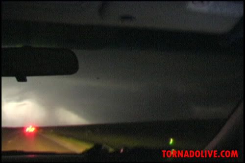
Greensburg Tornado and the new EF-5 Rating
First of all, my heart goes out to those affected by the Greensburg, KS tornado. That town was completely obliterated. It was a horrible thing. This tornado was HUGE, 1.7 miles wide at one point. Visit http://tornadolive.com/ to see a few videos and stills of this monster.
The new Enhanced Fujita rating scale for tornadoes is a bit confusing, but this article from WDEF News has a great description of how this new rating system works, and why you can't compare an EF5 to an F5 from the past.
The new Enhanced Fujita rating scale for tornadoes is a bit confusing, but this article from WDEF News has a great description of how this new rating system works, and why you can't compare an EF5 to an F5 from the past.
Thursday, March 1, 2007
March 1, 2007 - Severe Wx
March certainly came in like a Lion. With severe weather predicted for February 28th and March 1st, I expected to end up spotting during this event. As usual for our area, the weather came in after dark. WAY after dark.
At around 3:30 AM the weather alert went off for counties to the west of Christian. My wife started monitoring for their safety, and I headed out. There was a reported wall cloud moving from the Republic area to the South Springfield area. I headed up 160 highway and monitored from the Weaver Road area. I never did see a wall cloud or funnel (that I heard was reported).
At one point I thought I saw a lowering in the cloud base and headed east on James River. I couldn't confirm it, and it was moving way to fast to catch. Skywarn started reporting a storm coming out of Crane that was expected to go through the Highlandville area that was showing signs of rotation.
I headed back south to Nixa and was in the area of my neighborhood about 2 miles south of 14 highway in the 160 area, when I started getting pelted with dime to nickel size hail and very heavy rain. I popped into my house to check radar and saw a storm that was just to my south with signs of rotation. Just about the time I wondered why there wasn't a tornado warning, the box popped up. I sent the wife and kids back to the basement shelter and headed back out. By the time I could go about a mile south, net control indicated this thing was already 9 miles east of me. Wow! It was moving fast.
As it turned out, that was the storm coming out of Crane. There was no way I imagined that storm would have been already to the Nixa area by the time I got back from Springfield. Anyway, hats off to the guys manning Skywarn throughout the night. Nice work.
Note: This storm event ended up killing a 7 year old girl in the Cauldfield area. It hit much harder NW and SE of my area. My heart goes out to her family, and all of the families in the SE part of the country who were pummeled by this event. The NWS has a good review of the Cauldfield area tornado.
Wednesday, January 17, 2007
January 14th-16th - Devastating Ice Storm
The ice storm that hit the SW MO area in January was like nothing I have ever experienced. I've been in ice storms before. I've seen thicker ice on trees. I haven't, however, seen anything like this storm. My account with images can be seen by clicking here.
Subscribe to:
Posts (Atom)