Monday, January 23, 2012

Tornadoes Have Devastated Parts of AR, MS, TN and AL

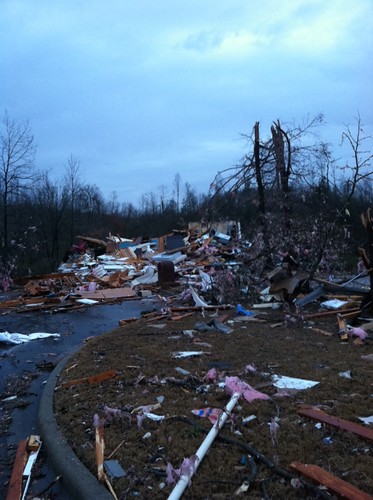
Aj2S2HqCIAIGWAj.jpg-large
During the evening and overnight hours of 1/22/12 and 1/23/12, tornadoes have ripped across parts of Arkansas, Tennessee, Mississippi and Alabama. Reports of damage and fatalities are still coming in. By the looks of some of these pictures, there were some strong tornadoes.

Please pray for the folks affected by these storms.

Please remember, no matter what time of year, have a NOAA All Hazards Radio ready to protect you and your family.

Thursday, January 19, 2012

NWS 2012 Spotter Training Calendar

The NWS Spotter Training Classes for 2012 have been posted. Please visit their website for the most up to date information for dates, times and locations. This training gets updated every year, so even if you've attended before, it's always a great refresher with some new information.

Tuesday, November 8, 2011

Severe Weather Expected Later Today

The National Weather Service in Springfield, MO is calling for the development of severe weather later today. Wind gusts of 60MPH and embedded tornadoes are possible with the line as it develops early this evening. The showers and thunderstorms during the early part of the day should remain below severe limits.

These risks later today include:
  • Limited tornado risk
  • Limited hail risk
  • Elevated thunderstorm wind damage risk
  • Elevated flooding risk
  • Significant lightning risk
** The Storm Prediction Center site appears to be down at this time. But the last indication was a slight risk box up through Arkansas and covering most of Missouri and eastern Kansas and Oklahoma.

You should stay tuned to local weather forecasts. Make sure your NOAA All Hazards Radio is on and backed up by battery. If you don't own a NOAA All Hazards Radio, you should. Click the link for a previous blog post on selecting one.


Monday, November 7, 2011

Severe Storms Possible - Tuesday 11/8/11

The Storm Prediction Center shows most of MO in a slight risk box for severe weather on Tuesday. The Springfield National Weather Service office lists the the primary threat being damaging straight line winds. Hail and an isolated weak tornadoes can not be ruled out.

You should stay tuned to local weather forecasts. Make sure your NOAA All Hazards Radio is on and backed up by battery. If you don't own a NOAA All Hazards Radio, you should. Click the link for a previous blog post on selecting one.


Wednesday, October 12, 2011

Few Strong to Severe Storms Possible Later Today and Tonight

The Storm Prediction Center has most of MO and AR, SE KS and NE OK in a slight risk box for severe weather. The National Weather Service in Springfield, MO is forecasting that few strong to severe storms will be possible later today and tonight.

These risks include:
  • Elevated hail risk
  • Limited thunderstorm wind damage risk
  • Significant lightning risk
You should stay tuned to local weather forecasts. Make sure your NOAA All Hazards Radio is on and backed up by battery. If you don't own a NOAA All Hazards Radio, you should. Click the link for a previous blog post on selecting one.


Tuesday, September 20, 2011

NWS Final Report on May 22, 2011 Joplin Tornado

The National Weather Service has released it's final report on the May 22, 2011 Joplin, MO EF-5 tornado.

The story can be found here.

A PDF version of the report can be found here.

The Springfield NWS assessment of the tornado can be found here.

Sunday, September 18, 2011

Severe Storms Possible - Sunday 9/18/11

Severe thunderstorms are possible late this afternoon into tonight in SW MO, NW AR, NE OK and SE KS. The Springfield NWS lists the risks as:

  • Limited Tornado Risk
  • Elevated Hail Risk
  • Elevated Thunderstorm Wind Damage
  • Limited Flooding Risk
  • Significant Lighting Risk
A Severe Thunderstorm Watch is in effect for far SW MO until 11 p.m.

You should stay tuned to local weather forecasts. Make sure your NOAA All Hazards Radio is on and backed up by battery. If you don't own a NOAA All Hazards Radio, you should. Click the link for a previous blog post on selecting one.