
Another incident where an outdoor event was not evacuated during a weather warning has occurred. This time in St. Louis, MO after a Cardinals/Brewers game. One person is dead, one hundred hurt, with five of them being critically injured. When will even planners be held accountable for ignoring weather warnings?
Link to story
Sunday, April 29, 2012


Friday, April 27, 2012
Strong to Severe Storms Possible Later Today

The Storm Prediction Center has NE OK, most of KS and Western MO in a slight risk box for severe weather. Far central Western MO and the Eastern portion of central KS are in a moderate risk box. The National Weather Service in Springfield, MO has listed the following risks for SW MO:
- Elevated Tornado Risk
- Significant Hail Risk
- Elevated Thunderstorm Wind Damage Risk
- Elevated Lightning Risk
- Limited Non-Thunderstorm Wind Risk
You should stay tuned to local weather forecasts. Make sure your NOAA All Hazards Radio is on and backed up by battery. If you don't own a NOAA All Hazards Radio, you should. Click the link for a previous blog post on selecting one.
Sunday, April 15, 2012
Severe Weather Likely Today
 The Storm Prediction Center has very far SE KS, E OK, AR and MO in a slight risk box for severe weather. Areas east of 65 are most likely to see any tornadic activity. The Springfield National Weather Service lists the risks as:
- Limited tornado risk
- Limited hail risk
- Elevated thunderstorm wind damage risk
- Limited flooding risk
- Significant lightning risk
- Elevated non-thunderstorm wind risk
The main threat appears to be east of highway 65 today. However, at the time of this blog post, there is currently a tornado warning in NE OK, that if it tracks into MO would track through parts of NW AR, then into Barry, Stone and Christian County. From what I can tell, this is not a current threat or concern for MO, I am only noting it to point out that tornadoes are still possible today in the Ozarks.
Saturday, April 14, 2012
Severe Weather Threat For SW MO
The severe weather threat has spread further east into MO. Sprinfield is now in the tornado threat area. While it isn't in the outbreak area, there is some threat. Please monitor local media.

KS, OK, NE and parts of MO and IA - Likely Tornadic Outbreak
 There will likely be a tornadic outbreak in KS, OK, NE, far Western MO and Western IA today. Please plan now and stay tuned to local weather conditions. The image to the right is the tornado percentage for today. Chases will be out with a 5 to 10 percent chance. Please note the highest areas today are up to 45 percent. This is a serious situation, please be careful.
If you live in these areas, you should stay tuned to local weather forecasts. Make sure your NOAA All Hazards Radio is on and backed up by battery. If you don't own a NOAA All Hazards Radio, you should. Click the link for a previous blog post on selecting one.
Friday, April 13, 2012
Severe Weather Expected Through Sunday
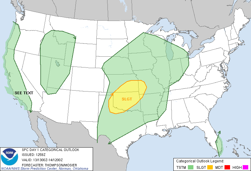 The severe weather threat over the next three days is pretty widespread. Please pay attention to local forecasts. Today, the Storm Prediction Center has a large area of OK, KS and SW MO in a slight risk box. This includes the threat of tornadoes, especially in OK. The threat of severe weather in SW MO is later tonight into the overnight hours, and mainly west of Highway 71.
There will likely be a tornado outbreak in OK and KS on Saturday, conditions are really coming together. If you live in these areas, please pay close attention to local forecasts.
SW MO will likely have the biggest chance for severe weather on Sunday.
You should stay tuned to local weather forecasts. Make sure your NOAA All Hazards Radio is on and backed up by battery. If you don't own a NOAA All Hazards Radio, you should. Click the link for a previous blog post on selecting one.
Tuesday, April 3, 2012
Subscribe to:
Posts (Atom)