Friday, May 31, 2013

UPDATED: Strong to Severe Thunderstorms This Afternoon and Evening

UPDATED 11:34am

Strong to severe thunderstorms will develop this afternoon into the evening.  The Storm Prediction Center has most of MO and OK, SE KS and NW AR in a slight risk for severe weather, with SE KS, much of OK and extreme SW MO in a moderate risk box for severe weather.  The slight risk area is listed with a 5-10% chance of a tornado, with the moderate risk area showing 15%.

The Springfield NWS office notes that the most likely time for storms to impact the Ozarks is between 2pm and 10pm this evening.  The risks include:
  • Elevated tornado risk
  • Elevated hail risk (up to golf ball sized hail)
  • Elevated thunderstorm wind damage risk (up to 70MPH wind gusts)
  • Elevated flooding risk
  • Significant lightning risk
  • Limited non-thunderstorm wind damage risk
Rainfall amounts are expected from 1 to 4 inches, so please pay attention to flooding possibilities.


You should stay tuned to local weather forecasts. Make sure your NOAA All Hazards Radio is on and backed up by battery. If you don't own a NOAA All Hazards Radio, you should. Click the link for a previous blog post on selecting one.


Strong to Severe Thunderstorms This Afternoon and Evening

Strong to severe thunderstorms will develop this afternoon into the evening.  The Storm Prediction Center has most of MO and OK, SE KS and NW AR in a slight risk for severe weather, with SE KS, much of OK and extreme SW MO in a moderate risk box for severe weather.  The slight risk area is listed with a 5% chance of a tornado, with the moderate risk area showing 10%.

The Springfield NWS office notes that the most likely time for storms to impact the Ozarks is between 2pm and 10pm this evening.  The risks include:
  • Elevated tornado risk
  • Elevated hail risk (up to golf ball sized hail)
  • Elevated thunderstorm wind damage risk (up to 70MPH wind gusts)
  • Elevated flooding risk
  • Significant lightning risk
  • Limited non-thunderstorm wind damage risk
Rainfall amounts are expected from 1 to 4 inches, so please pay attention to flooding possibilities.


You should stay tuned to local weather forecasts. Make sure your NOAA All Hazards Radio is on and backed up by battery. If you don't own a NOAA All Hazards Radio, you should. Click the link for a previous blog post on selecting one.


Thursday, May 30, 2013

UPDATED: Severe Weather Expected This Afternoon and Tonight

Tornado Watch until 9PM

Conditions have become more unstable, and the severe weather threat has increased for the Ozarks.  There is an active Tornado Watch until 9PM tonight that includes SW MO and surrounding areas.  The National Weather Service in Springfield now list today's risks as:
  • Elevated tornado risk
  • Elevated hail risk
  • Elevated thunderstorm wind damage risk
  • Significant flooding risk
  • Significant lightning risk

You should stay tuned to local weather forecasts. Make sure your NOAA All Hazards Radio is on and backed up by battery. If you don't own a NOAA All Hazards Radio, you should. Click the link for a previous blog post on selecting one.


Conditional Risk For Severe Weather Later Today and Tonight

If conditions provide atmospheric instability, then the possibility of severe weather is greater later this afternoon and tonight.  While there is a possibility of all modes of severe weather, the good news is that it appears that it will be limited in the Ozarks.

The Storm Prediction Center has most of MO, KS, OK and NW AR in a slight risk box for severe weather, and part of S KS and a good part of OK in a moderate risk box.  They list the tornado probability in much of the Ozarks at 5%, however, the Joplin area is in a 10% hatched area for stronger tornadoes.

The National Weather Service in Springfield, MO lists the threats as:
  • Limited tornado risk
  • Limited non thunderstorm wind risk
  • Significant lightning risk
  • Elevated hail risk
  • Elevated thunderstorm wind damage risk
  • Limited flooding risk
You should stay tuned to local weather forecasts. Make sure your NOAA All Hazards Radio is on and backed up by battery. If you don't own a NOAA All Hazards Radio, you should. Click the link for a previous blog post on selecting one.


Monday, May 20, 2013

Severe Storms Expected Later Today

Once again, the Storm Prediction Center has SW MO, Extreme SE KS, NE OK and NW AR in a moderate risk box for severe weather.  The Springfield NWS lists the risks as:
  • Elevated tornado risk
  • Significant hail risk
  • Significant thunderstorm wind damage risk
  • Elevated flooding risk
  • Significant lightning risk
Storms are expected to develop across eastern KS and OK again later this afternoon and move across the Ozarks into the overnight hours.  Golf ball sized hail, damaging winds in excess of 60 MPH and tornadoes are possible.

***Joplin area folks, your weather alert radios may not function properly, please see the NWS URGENT statement regarding the over the air alerting system.***

You should stay tuned to local weather forecasts. Make sure your NOAA All Hazards Radio is on and backed up by battery. If you don't own a NOAA All Hazards Radio, you should. Click the link for a previous blog post on selecting one.

Sunday, May 19, 2013

Strong Tornadoes Possible Today - Sunday 5/19/13

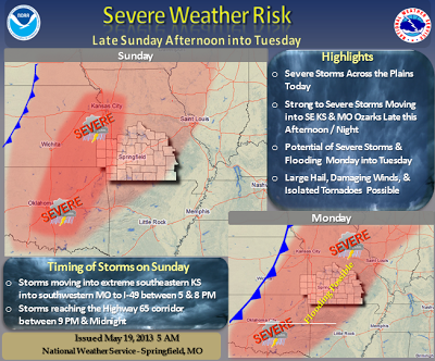
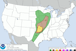
The Storm Prediction Center has Western Mo, Eastern KS and NE OK in a moderate risk box for severe weather today (the rest of the area is in a slight risk box).  Much of the area is in a 15% probability box for a tornado.  There is a possibility this will include STRONG tornadoes.  You still have time time to prepare.  At this time, the estimated timing for these storms will be 5pm for the SE KS/Joplin MO area, and between 9pm and midnight for the Springfield, MO area.

The Springfield NWS lists the threats as:

  • Elevated tornado risk
  • Significant hail risk
  • Significant thunderstorm wind damage risk
  • Limited flooding risk
  • Significant lightning risk
  • Limited non-thunderstorm wind risk
  • Limited fog risk

This could be our first big spring storm system, and it will continue through Monday.  Please be alert and prepared.  Run through your safety plan so you can act on it with short notice.

***Joplin area folks, your weather alert radios may not function properly, please see the NWS URGENT statement regarding the over the air alerting system.***

You should stay tuned to local weather forecasts. Make sure your NOAA All Hazards Radio is on and backed up by battery. If you don't own a NOAA All Hazards Radio, you should. Click the link for a previous blog post on selecting one.


Wednesday, May 15, 2013

Prepare For Severe Weather Now

The central US may see the first "big" round of Spring severe weather later this week.  If you do not own a NOAA All Hazards (Weather Alert) Radio, please strongly consider it.  If you are going to buy one, get one that lets you filter out unwanted warnings.  If you don't, you'll get tired of Flood Watch, Flood Warning, Flash Flood Watch, Flash Flood Warning, etc., and you will shut it off.  Invest the extra $20 for a radio that will let you filter down to YOUR county and the warnings you care about.

Here is a detailed posting about what you should look for.

Please consider this, and don't wait until the severe weather is here.  Prepare now so you can stress less later.  

Saturday, May 4, 2013

10 Year Anniversary of May 4, 2003 Outbreak

Today is the 10 year anniversary of the May 4, 2003 tornado outbreak.  Here is the Storm Prediction Center storm report from that day.  Here is the Springfield National Weather Service event review.  I also posted a blog post about that day, which is really what got me back into storm spotting after I had taken a break from it for a while.  Below is a video from Tom Trtan and Nick Penka as one of the large tornadoes moved towards Clever and Battlefield.  I know that there is cold weather and snow right now, but please remember it is prime storm season. If you don't own a NOAA All Hazards Radioyou should.